
Atlantis: The Antediluvian World is a long, illustrated book published in New York by Harper and Brothers in February 1882. Its author, the Minnesota politician Ignatius Donnelly, set out to prove that Plato's sunken island was real, that it lay in the middle of the Atlantic, and that every early civilisation on both sides of the ocean grew from it. He rested the case on the newest science of his day: soundings of the deep Atlantic floor.
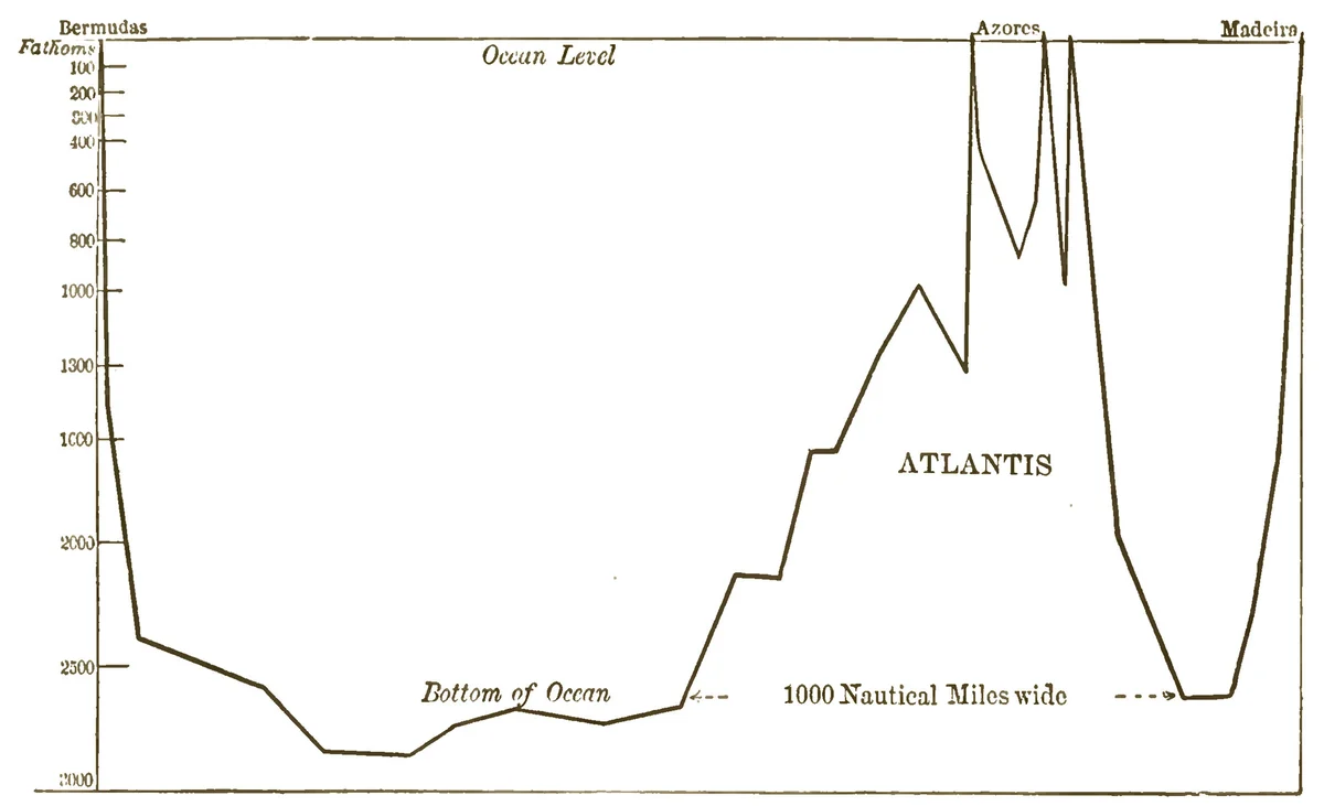
Open the book and the first thing in it, facing the title page, is a line drawn across a page. It runs flat along the bottom of the ocean from Bermuda, thousands of fathoms down. Then it climbs. A long slope, a shoulder, and a cluster of sharp peaks that break the surface at the Azores before dropping away again toward Madeira. Under the peaks, one word: ATLANTIS.
"As revealed," the caption says, "by the deep-sea soundings of H. M. ship 'Challenger,' and the U. S. ship 'Dolphin.'"
A mountain range nobody had ever seen, standing in the sea beyond the Pillars of Hercules, where Donnelly said Plato's island had been.
A congressman's book
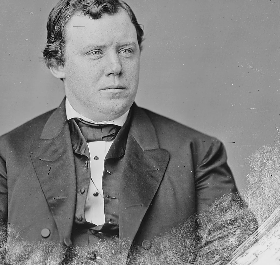
Donnelly was, in the words of the Minnesota Historical Society's encyclopedia, "the most widely known Minnesotan of the nineteenth century." Born in Philadelphia in 1831, he moved west in 1857 and, with a partner named John Nininger, promoted a town site on the Mississippi north of Hastings. He was lieutenant governor of Minnesota from 1860 and sat in Congress from 1863 to 1869. By 1882 he was out of office, living in the town that bore his partner's name, and reading.
The book was the result. It opens with a list. "This book is an attempt to demonstrate several distinct and novel propositions," Donnelly wrote, and there are thirteen of them. That there was once "a large island, which was the remnant of an Atlantic continent, and known to the ancient world as Atlantis." That Plato's description of it was "not, as has been long supposed, fable, but veritable history." That Atlantis "was the region where man first rose from a state of barbarism to civilization." That it was "the true Antediluvian world; the Garden of Eden," and that it "perished in a terrible convulsion of nature," leaving survivors who carried "the tidings of the appalling catastrophe" east and west, where it survived "in the Flood and Deluge legends of the different nations."
He knew what he was up against. "The fact that the story of Atlantis was for thousands of years regarded as a fable proves nothing."
The story itself, Plato's account of an island beyond the Pillars of Hercules told to Solon by the priests of Sais, is the subject of its own investigation: Atlantis in the Timaeus and the Critias. Donnelly took Plato at his word. Then he went looking for the island.
The testimony of the sea
He found it, he wrote, on the bottom of the ocean. "Deep-sea soundings have been made by ships of different nations; the United States ship Dolphin, the German frigate Gazelle, and the British ships Hydra, Porcupine, and Challenger have mapped out the bottom of the Atlantic, and the result is the revelation of a great elevation." It ran from near the British Isles down to South America and across to Africa, rising "about 9000 feet above the great Atlantic depths around it," and in the Azores, St. Paul's Rocks, Ascension and Tristan d'Acunha "it reaches the surface of the ocean."
His map on page 47 drew it in three parts: "Dolphin's Ridge," a great oval round the Azores with ATLANTIS written inside it; a "Connecting Ridge" curving toward Brazil; and a "Challenger Ridge" running south past Ascension. The surface of that ridge, he quoted from the Scientific American of 1877, "could never have been produced in accordance with any laws for the deposition of sediment, nor by submarine elevation; but, on the contrary, must have been carved by agencies acting above the water level." The Challenger's officers had found it "covered with volcanic deposits." And, he wrote, "a member of the Challenger staff, in a lecture delivered in London, soon after the termination of the expedition, gave it as his opinion that the great submarine plateau is the remains of 'the lost Atlantis.'"
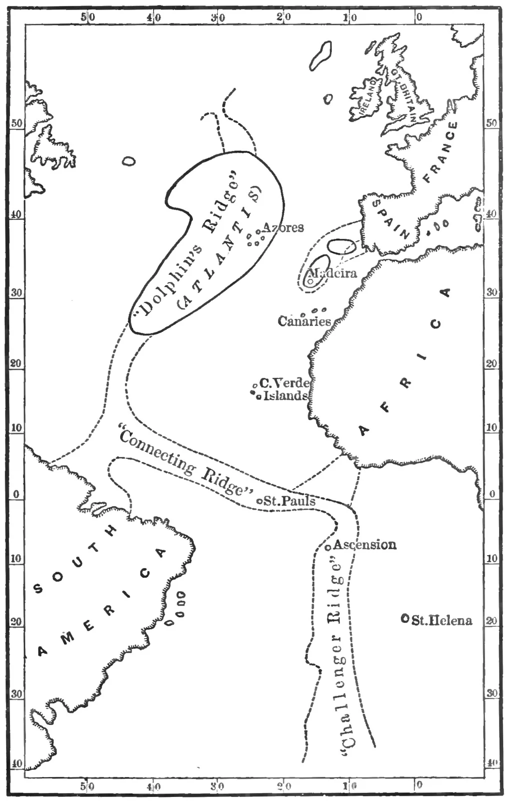
Here, Donnelly wrote, was "the backbone of the ancient continent which once occupied the whole of the Atlantic Ocean."
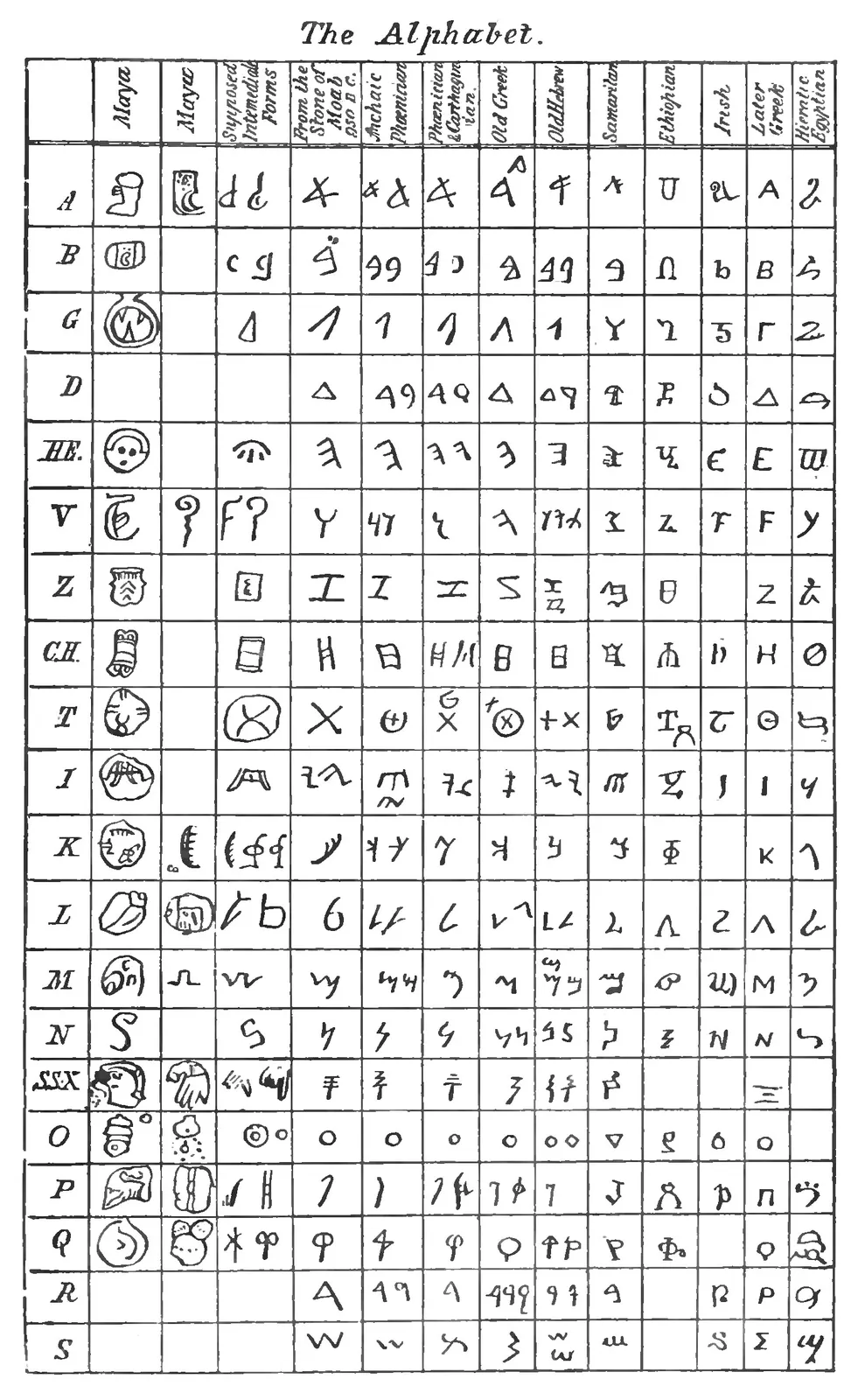
The rest of the book piled the evidence on top: flood stories from Babylon to Mexico, pyramids on both sides of the ocean, and a table on page 219 setting the Maya signs recorded by the sixteenth-century bishop Diego de Landa beside Phoenician, Hebrew and Egyptian letters. "We have thirteen letters out of sixteen in the Maya and Egyptian related to each other," he wrote. "Can any theory of accidental coincidences account for all this?"
The book was an immediate success. By 1890, the historian Donald DeMeules found in Donnelly's papers, it had gone through twenty-three editions in the United States and twenty-six in England. The British prime minister, William Gladstone, wrote to him in March 1882: "I may not be able to accept all your propositions, but I am much disposed to believe in an Atlantis." Six years later the founder of Theosophy, Helena Blavatsky, sent the readers of The Secret Doctrine to "the chart adapted from the Challenger and Dolphin soundings in Donnelly's Atlantis." The modern Atlantis begins here.
If the ridge was land
Set aside for a moment whether Donnelly was right. Ask the larger question. What would it mean if the ridge under the Atlantic had stood in the air within human memory?
It would mean Plato was writing history. The priests of Sais would have been keeping a record, and the dialogue that many readers over two thousand years took for a parable would be the oldest surviving account of a real place.
It would mean the story of civilisation has a missing first chapter. Egypt and the Maya, the Phoenicians and the builders of Peru, would be cousins, the scattered colonies of one drowned homeland, and the parallels between them would be family resemblance rather than coincidence.
It would mean the flood stories are memory. The tablets of Babylon, the stories of Mexico and the Bible's own account would be the same catastrophe, seen from different shores by the people who escaped it.
And it would leave a question that is still in front of us. If a land that size could go under the sea in a single convulsion, and our species could forget it everywhere except in its old stories, then the ground under any civilisation is less permanent than we assume. Donnelly put it as a hope: that the book would "widen the area of human history."
A ridge that is new
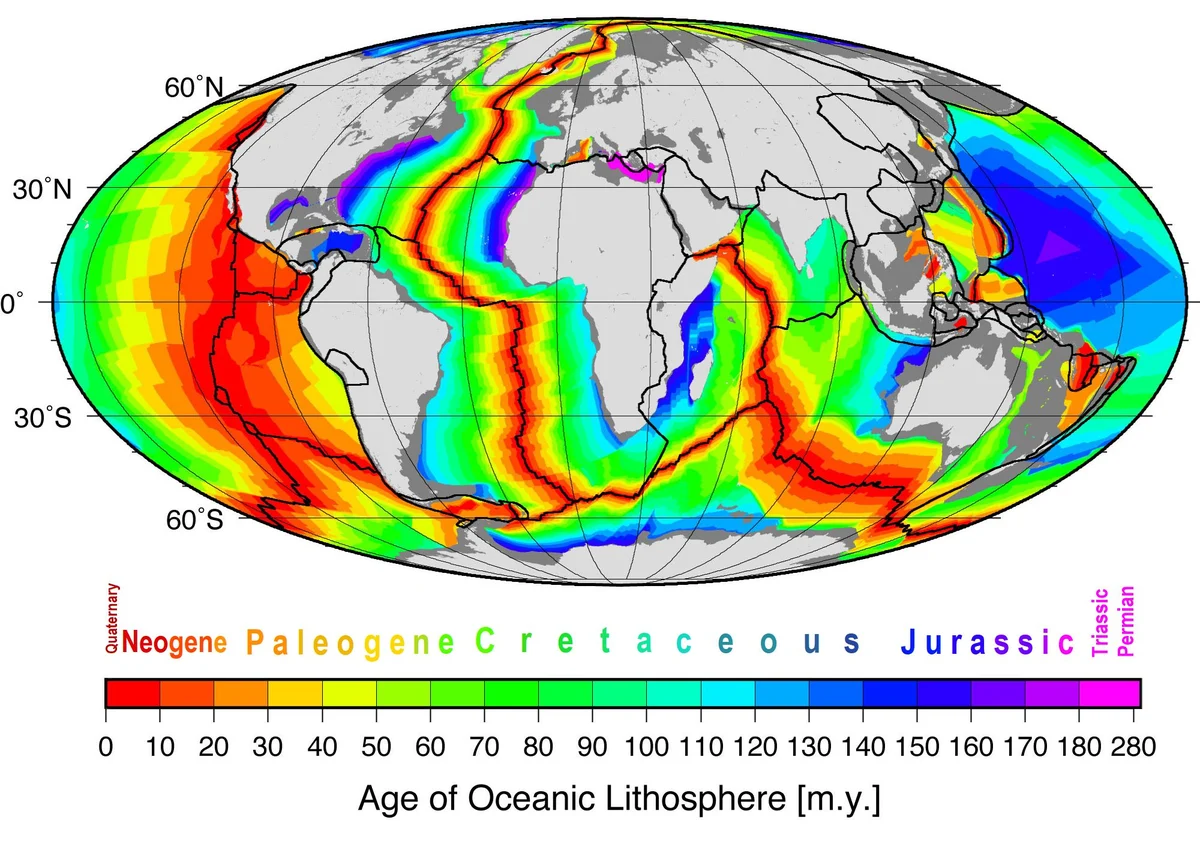
The standard account accepts Donnelly's ridge and explains it the other way round. The Mid-Atlantic Ridge is real, and it is enormous. But on the account the US Geological Survey gives, it is not a continent that sank. It is where the sea floor is being made.
In the early 1960s geologists proposed that mid-ocean ridges "mark structurally weak zones where the ocean floor was being ripped in two lengthwise along the ridge crest," where new magma "eventually erupts along the crest of the ridges to create new oceanic crust." The test was the age of the rock. If the theory was right, the rocks would be youngest at the crest and older with every mile away from it, in matching stripes of magnetic polarity on either side. In 1968 the drilling ship Glomar Challenger criss-crossed the ridge between South America and Africa and dated its cores. They provided, in the Survey's words, "the clinching evidence that proved the seafloor spreading hypothesis." The ridge is still spreading, at two to five centimetres a year, according to NOAA.
Donnelly's other evidence has its own answers. His Maya "alphabet" came from Landa's list, which the epigrapher David Stuart describes as "a misrepresentation of a syllabary": Landa had "fundamentally misunderstood syllable signs as alphabetic elements." The American scholar Daniel Brinton had suggested the same in 1879, three years before the book. And DeMeules, writing in Minnesota History in 1961, described the method: Donnelly "appropriates evidence of geologic change which took place over millions of years and uses it as proof of happenings which, according to his own argument, occurred in near-historic times," on the assumption "that all similarities in human cultures must necessarily arise from some common origin."
What the drill cores do not reach
The standard account answers the ridge. It does not take the ridge away.
Donnelly did not invent the mountains. The soundings were real, and so is the rise they found, with volcanic peaks that break the surface beyond the Pillars of Hercules. Reading it as sunken land was Donnelly's step; the ridge itself was the best science of 1882, and it still is.
The Challenger lecturer is unnamed. Donnelly gave no name, no date and no hall, and his book is the only source for the remark; the research for this investigation found no record of the lecture. Naming the speaker would show who held the opinion, not that the ridge was land.
Gladstone's letter said what it said, and no more. Donnelly used it to advertise the book and wrote in his diary that Gladstone "believed in the theory"; DeMeules, who read the original, judged him "not as enthusiastic as Donnelly chose to believe." A letter from Charles Darwin, who, DeMeules writes, had read it "with interest, but in a very skeptical spirit," stayed in Donnelly's files. And when Donnelly asked him to send a navy ship to sound Dolphin's Ridge, Gladstone answered, in DeMeules's summary, that he did not think the Admiralty would send out a scientific expedition "for the purely literary interest of Atlantis." No ship went for that purpose.
Plato calls Atlantis an island "larger than Asia (Minor) and Libya combined," in the translation Donnelly used, and Donnelly's first proposition calls it the "remnant" of a continent. Seafloor spreading explains the ridge; it does not, by itself, rule out a smaller island lost in a later age. No such island has been reported in the surveys this investigation drew on.
Still in print
Donnelly had hoped, his diary says, that the book would be "a great financial success and lift me out of this slough of debt and poverty." It did not quite. He went back into politics, ran for governor of Minnesota for the People's Party in 1892 and lost, wrote a bestselling novel and a book arguing that Francis Bacon wrote Shakespeare, and died on 1 January 1901, the first day of the twentieth century.
The book has never gone out of print for long. A revised edition appeared in 1949, a Dover reprint in 1976, and it is still read for free online and in print-on-demand copies today. The writer L. Sprague de Camp, who called Donnelly "expert at arguing from a molehill of fact to a mountain of surmise," conceded in 1946 that "Donnelly's book became the New Testament of Atlantism, as Timaeus and Critias are its Old Testament."
What keeps it alive is the thing on its first page. Not the alphabet, not the flood stories. A depth profile. A line across the floor of the ocean that climbs, without warning, into a range of mountains in the middle of the Atlantic.
The ridge is there. Every map of the Atlantic floor drawn since shows it. What it is, a drowned country or a seam where the planet is still being made, is the argument Donnelly started, and the drill cores are the reason most geologists think it is over.
Questions This Leaves You With
Is there anything a person actually does with this?
Not with your own life, honestly. Whatever happened in the Atlantic, nothing in Donnelly's book points to a date, a danger or a preparation, and anyone who sells you one is selling something. The larger question is about evidence: how a reader tells a real discovery, like a mountain range under the sea, from the story built on top of it. That question comes up in every field and every newspaper, and it is not yours alone to answer. This book is a good place to practise it.
Does this sit against a religious account of the world?
It can be read both ways, and serious people have read it both ways. Donnelly himself thought his propositions would "confirm in many respects the statements in the opening chapters of Genesis," with Atlantis as Eden and the flood as its end. Other readers have seen in the same idea a rival to scripture, a pagan prehistory written over a sacred one. This site will not tell you which way it falls for you. The ridge on the ocean floor says nothing about God either way.
Does this change what a human life is?
Hold your own life against the scale in this story: a mountain range that took millions of years to rise from a seam in the sea floor, still widening by two to five centimetres a year. One way of seeing it makes a life smaller; a human lifetime moves the Atlantic a few metres. The other makes it larger; we are the only creatures who have measured it, from a ship, with a weighted line. Which did you feel?
What would change your mind, in either direction?
Name it now, before you are committed, because it is harder later. Toward Donnelly: continental rock, not young ocean crust, cored from the ridge; or worked stone, roads or harbours found on a drowned surface near the Azores, securely dated to human times. Toward the standard account: what is already in hand, the drill cores and the magnetic stripes, together with the Maya signs read as syllables rather than letters. Notice that the first list asks for something new to be found, and the second points at what has been.
Who gave the Challenger lecture?
This is a small gap, and a real one. Donnelly's most striking witness is an unnamed member of the Challenger staff who, in a London lecture soon after the voyage, called the Atlantic plateau "the lost Atlantis," and Donnelly's book is the only source for it. The expedition's scientific staff were few and are known by name. The research for this investigation did not match the remark to any of them, to a date or to a printed text. If it was said, it was said by someone connected with the expedition, and whether it was a scientist's guess, a joke or a reporter's paraphrase is still an open question.
Sources
- Atlantis: The Antediluvian World (1882), University of Toronto copy Ignatius Donnelly, Harper and Brothers; Internet Archive Primary record
- Atlantis: The Antediluvian World, Project Gutenberg eBook 4032 Ignatius Donnelly; Project Gutenberg Primary record
- Ignatius Donnelly: A Don Quixote in the World of Science, Minnesota History 37:6 (1961) Donald H. DeMeules, Minnesota Historical Society Study
- Donnelly, Ignatius (1831-1901), MNopedia Rhoda R. Gilman, Minnesota Historical Society Study
- The Secret Doctrine, vol. 2 (third edition) H. P. Blavatsky; Project Gutenberg Primary record
- This Dynamic Earth: Developing the theory U.S. Geological Survey Primary record
- What is a mid-ocean ridge? NOAA Ocean Exploration Primary record
- Archives: Daniel Brinton's Letter on Landa's Alphabet (2013) David Stuart, Maya Decipherment Study
- Lost Continents, Natural History, May 1946 L. Sprague de Camp, Natural History Study
- Donnelly, Ignatius, legislator record Minnesota Legislative Reference Library Primary record