
In the 1750s the French royal geographer Philippe Buache printed a map of the far south that showed something nobody had seen: a continent around the South Pole, cut almost in two by a frozen inland sea. Antarctica would not be sighted for more than sixty years. Since the 1960s his map has been read as a picture of that continent without its ice.
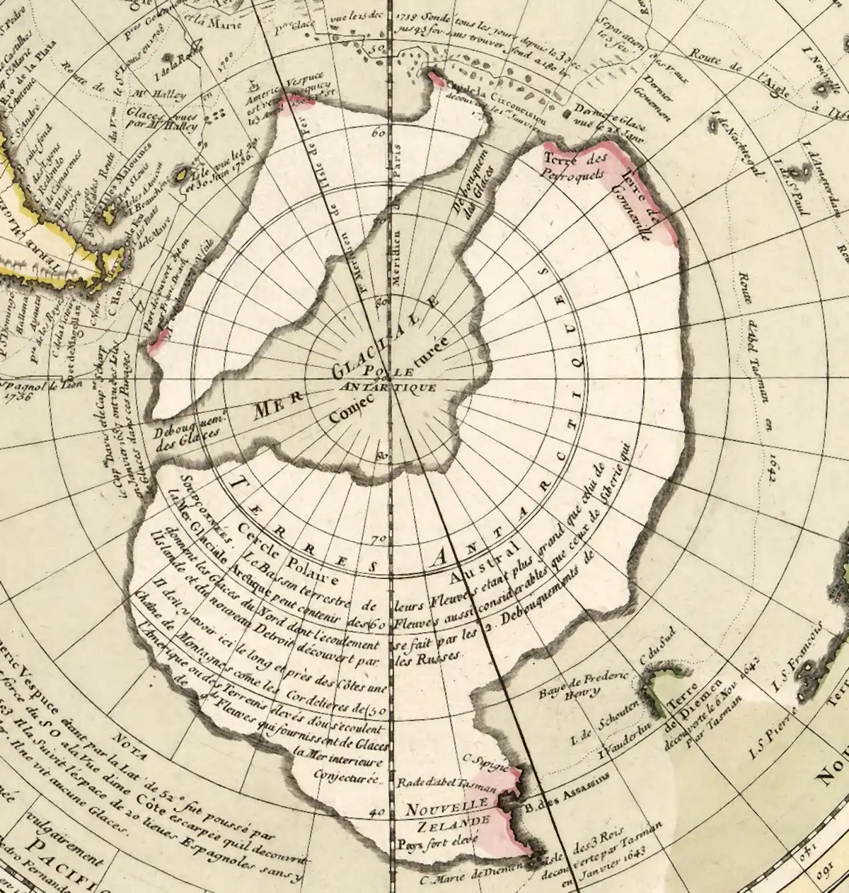
It is a round map, centred on the pole, the world seen from underneath. Africa and South America hang at the top and left in pink and yellow wash. Below them, filling the middle of the sheet, is a great land with a ragged coast, and in the very centre of it a pale sea spreading out from the pole. Two arms of that sea run out through the land to the ocean.
Across the sea, in small engraved capitals, one word: GLACIALE.
A map in two states
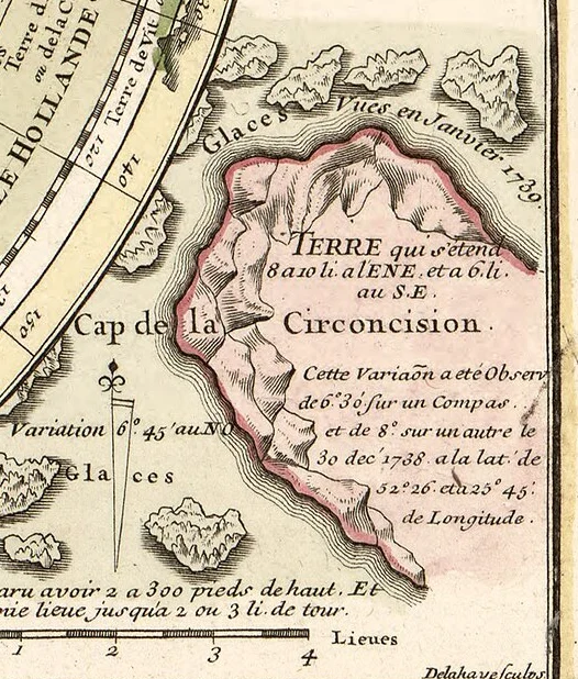
The map is the Carte des Terres Australes, "the map of the southern lands between the Tropic of Capricorn and the Antarctic Pole," and it exists in two versions. The first was published in Paris under a privilege dated 5 September 1739, to show what the navigator Jean-Baptiste Bouvet de Lozier had found on a voyage for the French East India Company. Bouvet had sailed in 1738 with two frigates looking for the southern continent, and on 1 January 1739, the map records, sighted "une Terre fort haute," a very high land, at 54 degrees south. He named it the Cape of the Circumcision and spent twelve days trying to land, held off "a cause des Glaces, de la Brume, et des vents contraires," by ice, fog and contrary winds. An inset in the corner shows his sketch of the cape and of icebergs he reckoned at "2 a 300 pieds de haut," two to three hundred feet high.
In that first version the land around the pole is blank.
The second version adds a line to the title cartouche: "Augmentee de diverses vues Physiques &c. 1754," enlarged with various physical views. Now the polar interior is filled. A continent rings the pole, and across it runs the sea, labelled "MER GLACIALE" and "Conjecturee." Two outlets, each marked "Debouquement des Glaces," mouth of the ice, carry it out to the ocean, one near Bouvet's cape and one toward Cape Horn. Both copies of this state examined for this investigation, at the Bibliotheque nationale de France and the Library of Congress, also carry the track of a Spanish ship in 1756, so the plate as printed is no earlier than that year.
Buache was a member of the Academie des Sciences and son-in-law of the great geographer Guillaume Delisle, as the cartouche says. He explained himself to his colleagues on 30 July 1754, in a memoir on the southern and Antarctic lands. He was preparing, he said, research on "la mer Glaciale que je conjecture etre sous le Pole," the frozen sea "that I conjecture to be under the Pole," and he presented a map of the southern hemisphere carrying conjectures "conformement a d'anciennes relations & a diverses vues physiques," in keeping with old accounts and with various physical views. Most of the memoir is about something else, a Dutch chart of the coast of New Guinea. The map he presented is very likely this one, though the memoir does not name it.
Old accounts.
The continent under the ice
In 1966 the American historian Charles Hapgood put Buache's map into Maps of the Ancient Sea Kings, the book that argued that old maps preserved a lost, ice-age knowledge of the world. He printed it as his Figure 56, captioned "Sub-glacial topography of Antarctica, suggested by the 18th century French geographer Buache," beside a map of the continent's rock surface from the seismic surveys of the International Geophysical Year of 1957-58.
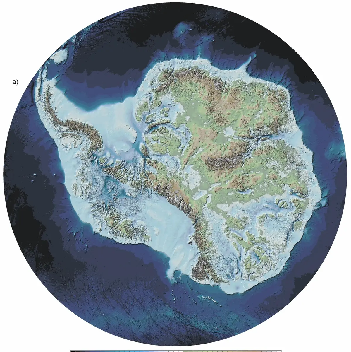
The IGY map showed something new: much of the rock under West Antarctica lies below sea level. "There is no western shore to the Ross Sea," Hapgood wrote; "the rock surface of the continent is below sea level straight across from the Ross Sea to the Weddell Sea." Strip off the ice and the sea would flood in. Against that, Buache's map "may show the continent at a time when there was no ice at all," Hapgood wrote. "If an apparent error in the orientation of the continent to other land masses is disregarded, it is quite easy to imagine that this map shows the waterways connecting the Ross, Weddell, and Bellingshausen Seas."
Graham Hancock took the reading further in Fingerprints of the Gods (1995). Buache's map, he wrote, "seems to have been based on source maps made earlier, perhaps thousands of years earlier," and gives "an eerily precise representation of Antarctica as it must have looked when there was no ice on it at all." The French academician, Hancock wrote, "depicted a clear waterway across the southern continent dividing it into two principal landmasses," something the IGY survey "only confirmed." On Hancock's reading the source went back to around 13,000 BC.
Two things give the reading its pull. Buache drew land around the pole where there turned out to be a continent. And he drew it divided by water, where the rock beneath the ice does lie below the sea in deep basins. That is a resemblance, not a match: his land reaches far north of the Antarctic Circle, much larger than the real coast, and Hapgood himself had to set aside its orientation.
If the sea was real
Set aside for a moment whether the reading is right. Ask the larger question. What would it mean if a geographer in Paris in the 1750s held a true picture of Antarctica without its ice?
It would mean the "anciennes relations" were not travellers' tales or the charts of known voyages, but charts drawn by someone who had seen the continent bare, and copied, and copied again, until they reached an academician's desk.
It would mean Antarctica had been free of ice within the memory of map-makers. The ice sheet that now covers the continent would be, on that reading, younger than the knowledge of the land beneath it.
It would mean our species, or some part of it, had sailed and surveyed the bottom of the world before any history we have of ships. Our own account of exploration, from Cook's circumnavigation to the first sighting in 1820, would be a rediscovery.
And it would leave the question that Hapgood and Hancock both left: where are the source maps? If they reached Paris in the eighteenth century, they passed through hands, archives and libraries that still exist.
A sea he called a guess
The standard account starts with Buache's own words. He called the sea a conjecture, in his memoir and twice on the map: "Conjecturee," and, in a long note across the continent, "la Mer interieure Conjecturee." The 1739 version of the map, drawn from Bouvet's report, shows no continent at all. The continent and the sea appear only in the later state. The same frozen sea appears in a small round inset on his physical map of the Pacific, published in 1754, so it was his idea before this plate was enlarged. A theory added to a discovery map, on this account, rather than a copy of an older one.
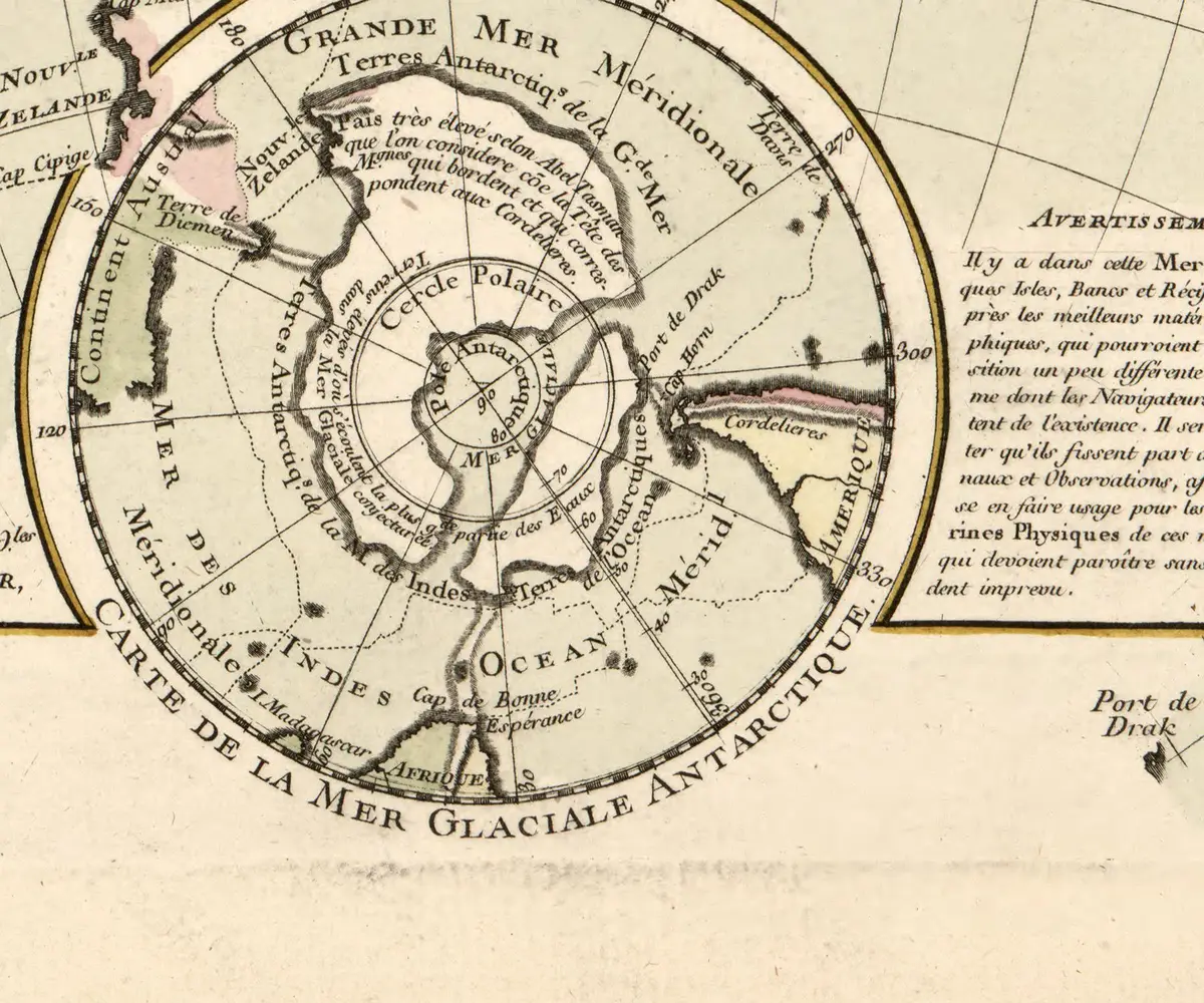
The note on the map explains the theory. Along the coast there must be "une Chaine de Montagnes come les Cordelieres de l'Amerique," a mountain chain like the Andes, from which great rivers flow and fill "la Mer interieure Conjecturee" with ice. Bouvet's icebergs, hundreds of feet high, needed a source. Buache reasoned by analogy with Siberia, whose rivers feed the ice of the Arctic, and with his own theory that mountain chains run on under the sea. He never says, in the memoir he read, what his "anciennes relations" were. He mentions Marco Polo, Abel Tasman and a Dutch chart, but in a passage about New Guinea, not about the polar sea.
Then the modern maps. With the ice removed, West Antarctica's bed does lie largely below sea level, and seaways would open across it. But a 2011 study by David Vaughan and colleagues at the British Antarctic Survey, in Geochemistry, Geophysics, Geosystems, found "a direct Ross Sea to Weddell Sea (R-W) seaway is extremely unlikely." The likely channels run through the Amundsen Sea sector instead. And most of the rock below sea level is not in the west at all: the Bedmap2 survey of 2013 found that more than 73 percent of the ice sheet's area grounded below sea level is in East Antarctica. The sea on Buache's map, by its labels, runs from the Cape Horn sector to the sea near Bouvet's cape, in the Atlantic sector, and not to the Ross Sea at all.
What the theory does not reach
The standard account explains where Buache's sea came from. It does not explain away everything the map got right.
Buache drew a southern continent on a map before anyone had seen one. That much the old map-makers did as a matter of routine; the great southern land had filled the bottom of world maps for two centuries, as on Oronce Fine's map of 1531, told in The 1531 Map That Named a Continent Nobody Had Seen. But Buache's has a pole-centred shape and an inland basin, and Antarctica, under its ice, has basins of rock far below the sea.
His "anciennes relations" are named only in general. In the 1754 memoir he gives no list of the sources behind the southern sea, and he promised more "dans la suite," in a later paper, which was not found for this investigation. Which old accounts he had open on his desk when he drew the outlets is not known.
And the date "1737" that circulates with the map belongs to a different map. Hapgood dated to 1737 a Buache chart of the Atlantic between Africa and America; Hancock wrote that Buache "published his map of Antarctica in 1737." The Antarctic map with the sea is from the 1750s.
Nobody has found a chart older than Buache's that shows the same sea.
The ice and the rock
Buache's sea was a guess about where icebergs come from, and on the record of his own words he knew it was a guess. He was right that the far south held land, and right that it was cold enough to make ice in vast quantities. He was wrong about rivers and mountains like the Andes ringing an inland sea. The continent was first sighted in 1820, and the ice that covers it, now shared under the Antarctic Treaty, buries most of the rock.
What lies under that ice was the twentieth century's discovery, and it is still being refined. In 2025 the Bedmap3 survey put 46.7 percent of the grounded area of Antarctica below sea level. A continent of rock, much of it sunk beneath the sea and pressed down by the weight above it, with deep troughs and basins in places no ship has ever floated.
So the strange thing about the map is not that it is right. It is that it is close to a kind of right. A sea drawn across a continent by a man reasoning from icebergs, two hundred years before radar looked through the ice and found that the rock below is broken by basins of its own.
Questions This Leaves You With
Is there anything a person actually does with this?
Not with your own life, honestly. A map of the 1750s has no date in it for anything to come, and anyone who sells you one is selling something. The larger question is how an educated guess differs from knowledge, and how we would tell them apart in an old document. That question is open, and it applies to every map made before the places on it were visited. It is not yours alone to answer.
Does this sit against a religious account of the world?
It can be read both ways, and serious people have read it both ways. Some readers find in the idea of a lost, advanced age an echo of the old traditions of a world before a flood; others see nothing in an eighteenth-century map that touches what they believe. This site will not tell you which way it falls for you. Buache's own reasoning, set out in his memoir, is about rivers, mountains and ice, not about scripture.
Does this change what a human life is?
Hold your own life against the scale in this story: an ice sheet over a whole continent, and under it a continent's worth of rock pressed below the sea. One way of seeing it makes a life smaller; the ice has lain there far longer than our species has had maps. The other makes it larger; a man with a pen in Paris reasoned from icebergs about a place nobody had seen, and the guess has held readers' attention for two and a half centuries. Which did you feel?
What would change your mind, in either direction?
Name it now, before you are committed, because it is harder later. Toward an older source: a chart securely dated before Buache, showing the same divided continent and the same outlets, from a source that could not have had his theory; or Buache's own notes naming such a chart. Toward the standard account: what is already in hand, his memoir calling the sea a conjecture, the blank 1739 state, and a modern bed map whose seaways do not run where his do. Notice how much turns on finding one older sheet.
What were the "old accounts"?
This is the real gap. Buache told the Academie that his conjectures followed "anciennes relations," and in the memoir he read he named no source for the inland sea. He promised more in a later paper, which was not found for this investigation. If that paper exists and lists what he drew from, it would settle, in his own words, whether the sea came from a book or from his reasoning. No one on either side has been found quoting it.
Sources
- Cartes et tables de la geographie physique ou naturelle (1757), sheet: Carte des Terres Australes Philippe Buache; Library of Congress, Geography and Map Division Primary record
- Carte des terres australes ... 1754, catalogue record Bibliotheque nationale de France Primary record
- Carte des Terres Australes, first state (1739), BnF scan Philippe Buache; Bibliotheque nationale de France via Wikimedia Commons Primary record
- Considerations geographiques et physiques sur les Terres Australes & Antarctiques, Memoires de l'Academie royale des sciences, annee 1755 (1761) Philippe Buache, Academie royale des sciences Primary record
- Cartes et tables (1757), sheet: Carte physique de la Grande Mer, with the inset Carte de la Mer Glaciale Antarctique Philippe Buache; Library of Congress, Geography and Map Division Primary record
- Maps of the Ancient Sea Kings (1966; 1996 edition), pp. 65-67, 92-93 Charles H. Hapgood, Chilton Books / Adventures Unlimited Press Primary record
- Fingerprints of the Gods (1995), 'Mercator and Buache' Graham Hancock, Heinemann / Crown Primary record
- Potential seaways across West Antarctica, Geochemistry, Geophysics, Geosystems 12, Q10004 (2011) D. G. Vaughan, D. K. A. Barnes, P. T. Fretwell, R. G. Bingham; NERC Open Research Archive Study
- Bedmap2, The Cryosphere 7, 375-393 (2013) P. Fretwell et al., Copernicus / EGU Study
- Bedmap3, Scientific Data (2025) H. D. Pritchard et al. Study