
Tartary is the name that lies across northern Asia on the old maps of Europe. On the sheet Abraham Ortelius printed in his atlas of 1570 it stands in spaced capitals east of the Caspian, and the land around it, from the edge of Muscovy to the eastern ocean, is given to it.
A man sits in the mouth of a great tent. The engraved Latin names him Magnus Cham, a title that in the Tartars' tongue is said to mean emperor, the greatest prince of Asia. The towns crowd the south and east. Across the north the paper has tents, pitched on blank ground, and beside each tent a name: Bascirdorum horda, Chiesanorum horda, Mecritorum horda. Two of the hordes carry names out of the Bible, the Danites and the Nephthalites. Toward the eastern coast a legend remembers a Christian kingdom under Prester John, and remembers it in the past tense.
In the corner a cartouche states what the sheet is for. All Tartary, it says, and the rest of eastern Asia, obedient to the Great Khan.
One word, and one ruler over it. Within about three hundred years the word had left the land.
The Encyclopedia and the Forum
In April 2018 a user named KorbenDallas, on the forum stolenhistory.org, opened a thread with a title that promised an empire hidden in history. A capture saved two days later is why it can still be read. He started from a book anyone could open: the first edition of the Encyclopaedia Britannica, 1771, and an entry so short it fits on one page of volume three.
The entry calls Tartary "a vast country in the northern parts of Asia", bounded by Siberia on the north and west, and says "this is called Great-Tartary". Then it runs through the Tartars of Astracan, Circassia and Dagistan, the Calmucs, the Usbecs and Moguls, and those of Tibet. About seven lines. No ruler. No government. KorbenDallas set the word country against Wikipedia's phrase, a great tract, and wrote the sentence the thread stands on.
"Tartary was not a great tract. It was a country."
He kept going. The maps. A flag, a crest, an emperor, a genealogy, publications as late as 1865. And a number: Tartary Muskovite, the biggest country in the world, 3,050,000 square miles.
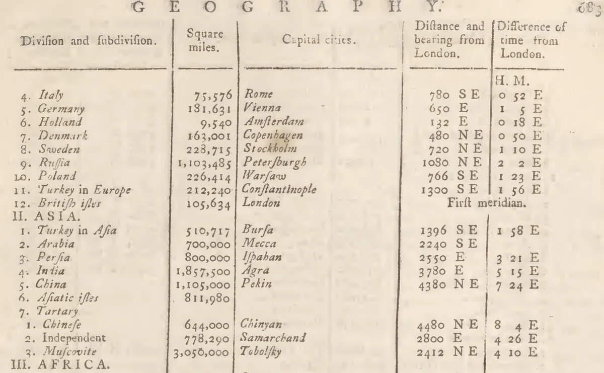
That number matches a row in a table in the same 1771 set. Volume two, pages 682 to 684, under GEOGRAPHY: a ruled grid of divisions, square miles and capital cities, set out to explain the encyclopedia's map plates. Italy, Germany, Russia, Persia, China. Then Tartary, and beneath it the row. Muscovite. Tobolsky. 3,050,000.
A Capital, a Flag and an Emperor
Read as KorbenDallas read it, that row is the biggest thing in the table. China on the same page is 1,105,000 square miles. India is 1,857,500. Russia, in its own row under Europe, is 1,103,485. Tartary Muscovite stands at almost three times that, with a capital city printed beside it.
The maps go on saying the name for centuries. Guillaume De L'Isle's Carte de Tartarie of 1706 was still being issued in Amsterdam in 1757. Nicolaes Witsen in Amsterdam gave a whole book the title Noord en Oost Tartarye, worked up from letters out of Russia, Dutch reports and old authors.
The flag is stranger. In 1756 Jacques-Nicolas Bellin, engineer at the French navy's chart office, published a great table of the flags that nations fly at sea. On its bottom row, near the two flags of China, are the Pav. de l'Empereur des Tartares, a dragon, and the Pav. de Tartarie, an owl. A naval office printed them for sailors, beside Morocco and Batavia.

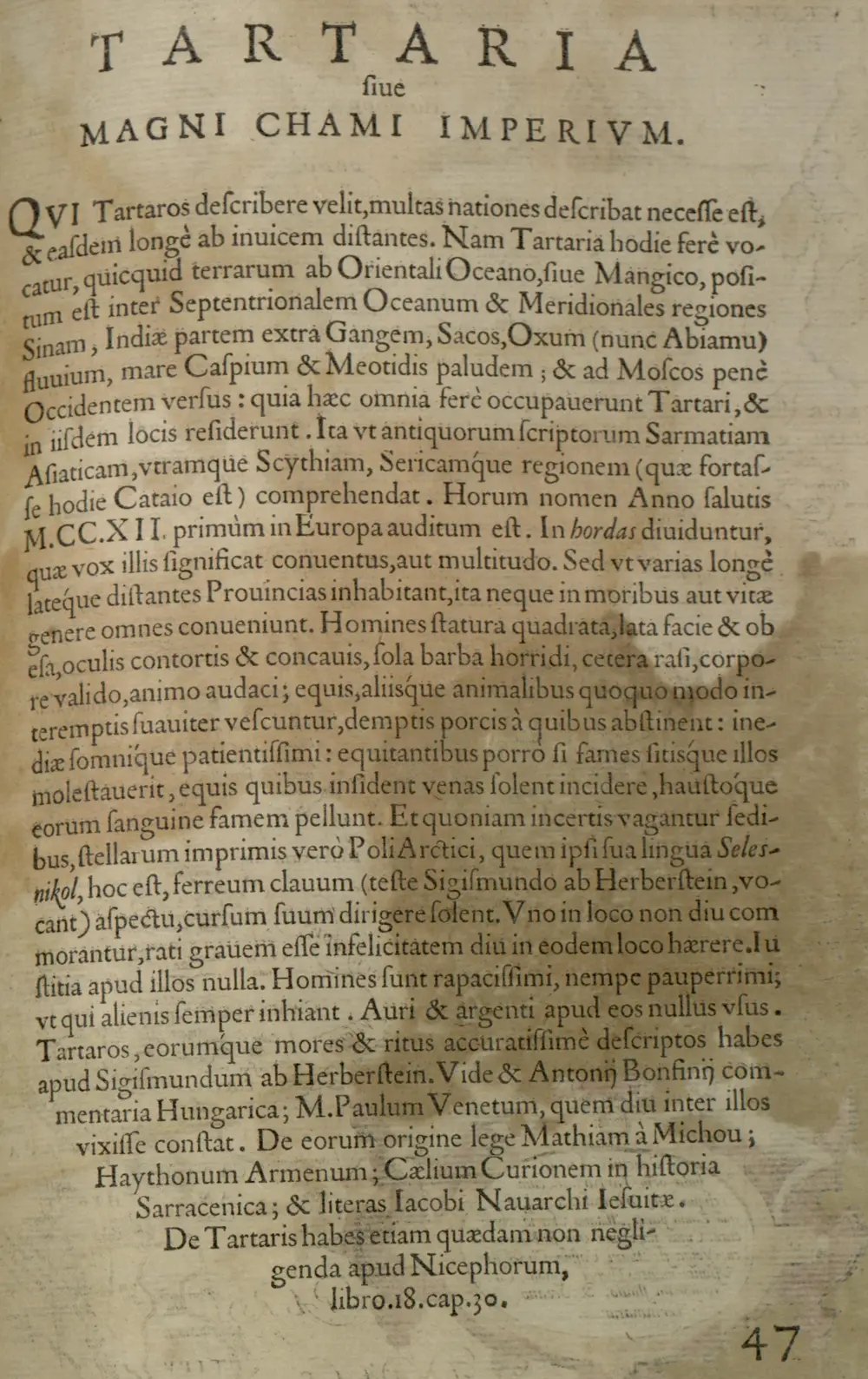
And there is the emperor. The heading over Ortelius's own text in the atlas reads Tartaria sive Magni Chami Imperium: Tartary, or the empire of the Great Khan. The catalogue record of Joan Blaeu's map gives the same title in the next century. Jodocus Hondius, on the plate of 1606, called it a regnum, a realm.
The Russian writers were there before the forum, and went further. Nikolay Levashov, as the Russian Geographical Society reports him, read the 1771 Britannica as a vast state of provinces under a central Great Tartary, its capital at Tobolsk, or Omsk, ruled by Rus. The same report has Anatoly Fomenko and Gleb Nosovsky putting its centre in Siberia and making its Tartars Slavs. Svetlana Gorshenina, a historian of the idea of Central Asia, records the sharpest form in nationalist writing: Tartary as the real name of Russia, pushed into oblivion by the West.
In English it moved fast. The Spinoff dated its traction to 2016, on YouTube channels that joined it to ideas about old buildings, and Brian Dunning of Skeptoid found little search interest before December 2018.
Put in its strongest form, the case is short. The maps show it. The encyclopedia measures it. The navy's chart office prints its flag. On that reading, the largest country on Earth was in print in 1771.
If the Row Is a Country
Set aside for a moment whether it is true. Ask the larger question. What kind of history are we living in if it is?
On that reading it would mean, first, that the map of Asia everyone learns is a replacement. The Siberia and the Manchuria of the schoolbooks would be names laid over something older, the way a new tenant paints a house. Tobolsk would not be a provincial town. It would be a fallen capital.
It would mean, next, that the two great land empires of the modern world took their eastern ground from a going concern. They would have inherited, or seized, a state almost three times the size of European Russia, and the handover would be missing from their records. Which would make the Russian advance across Siberia one of the great editing jobs in the human record, and every schoolroom map since a piece of the same work.
It would mean something harder about us. If the case holds, we have been wrong about how memory works. We would have to give up the comfort that a thing that large cannot be mislaid, that there are too many archives, too many treaties, too many ships in too many ports for a whole country to go missing. A state with a flag, a capital and three million square miles would have passed out of memory inside a century, in the age of printing, with its name still on the plates. Our sense of what we know would be, on that reading, a sense of what survived.
And one consequence is still in front of us. If a generation could lose a country that size, then every name on the map today would rest on the same trust, and nobody could say in advance what kind of archive would settle it.
What the Same Volumes Say
The standard account holds that Tartary was a name for a region and its peoples, not one state, and it starts on the same pages. Ortelius opens his text under that heading with a sentence that points that way: whoever would describe the Tartars must describe many nations, far from one another. Mark Elliott of Harvard, in "The Limits of Tartary" (2000), traces the word as a general European name for the little-known lands of Inner Asia, so loose that it needed Greater and Lesser, Eastern and Western, Chinese and Independent to mean anything. Amelia Raines of the Library of Congress reads Visscher's Tartaria of about 1657, with no coloured regions or borders, as no political designation.
No scholar was found writing about the Muscovite row, but the 1771 set reads it for itself. The column is headed Division and subdivision. Tartary, row seven, has no figure of its own. It has three rows under it with three capitals: Chinese, 644,000, Chinyan; Independent, 778,290, Samarchand; Muscovite, Tobolsky. Elsewhere the same set says "TOBOLSKI, the capital of Siberia", and "SIBERIA, or Asiatic Russia", and it calls Siberia a country too. On the next page the table lists a Land of Amazons, capital unknown, at 993,600 square miles.
Herman Moll, in 1712, called a surviving Great Cham of Tartary "that gross, but common Mistake", the Cham being the Emperor of China. Bellin wrote on his own sheet that he had gathered the flags from Dutch and English publications and did not guarantee their accuracy, and Flags of the World, citing Wilson's Flags at Sea, calls them probably fantasy.
On the standard account the interior was then surveyed and renamed. Jesuit mapping for the Kangxi emperor, Manchu and Russian expansion and the new word Manchuria took the eastern part away, and by 1814 Brue's map of Asia had kept only an Independent Tartary.
What the Paper Does Not Settle
Probably fantasy is a judgment, and the flags have not been traced to anyone. Bellin's came from somewhere. Flags of the World and the dealers say Carel Allard's Dutch shipbuilding book of 1694. A copy of the 1695 reprint, held at the Royal Library in The Hague, has 82 numbered flags ending with the Turkish ones, and no Tartar flag in the text or on the plates. Flags of the World describes them from the 1705 edition, so they may have come in later. The guesses at their owner run to Kazan, the Crimea and Siberia.
A flag at sea needs a ship. Official X looked for one, and for a port, a treaty or a witness that names that flag on the water, and for a ruler's act, a coin or an embassy from one government called Tartary. The search was limited and did not reach the archives. It did not find them.
The ground under the row is not empty, either. Some 17 kilometres from Tobolsk lie the remains of Qashliq, in the 16th century the capital of the Khanate of Sibir, a Siberian Tatar state. Yermak's Cossacks took it in 1582, and Tobolsk was founded nearby in 1587. Far to the west, Little Tartary, the Crimean Khanate, kept its dynasty until 1783, as a tributary of the Ottomans for much of that time. So there were Tatar states under the name, more than one, and Russia ended both. Neither was the country of the row. Each was real.
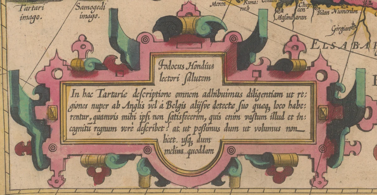
The mapmakers said how little they knew. Hondius wrote on his own plate that the map had not satisfied him, and asked who could truly describe that vast and unknown realm. The same trade printed the southern continent of Oronce Fine and the islands of the Zeno chart. What such a sheet records is what Europe had heard. How the interior was governed is a thing it had no way to know, in either direction.
And here is the strange part. By one witness, the name came with an erasure attached. William of Rubruck, travelling among the Mongols in the 1250s, reported that the Tatars were another people, defeated by them, and that the conquerors refused the name and would like to extinguish it. Europe gave it to them anyway. Matthew Paris punned on it under 1240, demons loosed from Tartarus, though Henry Yule thought the spelling with an r came through Armenian. So, on Rubruck's report, the West wrote across Asia a name its conquerors had wanted gone. The Tatars are still there, in Kazan and the Crimea and Siberia, and the name is still theirs.
The Name on the Water
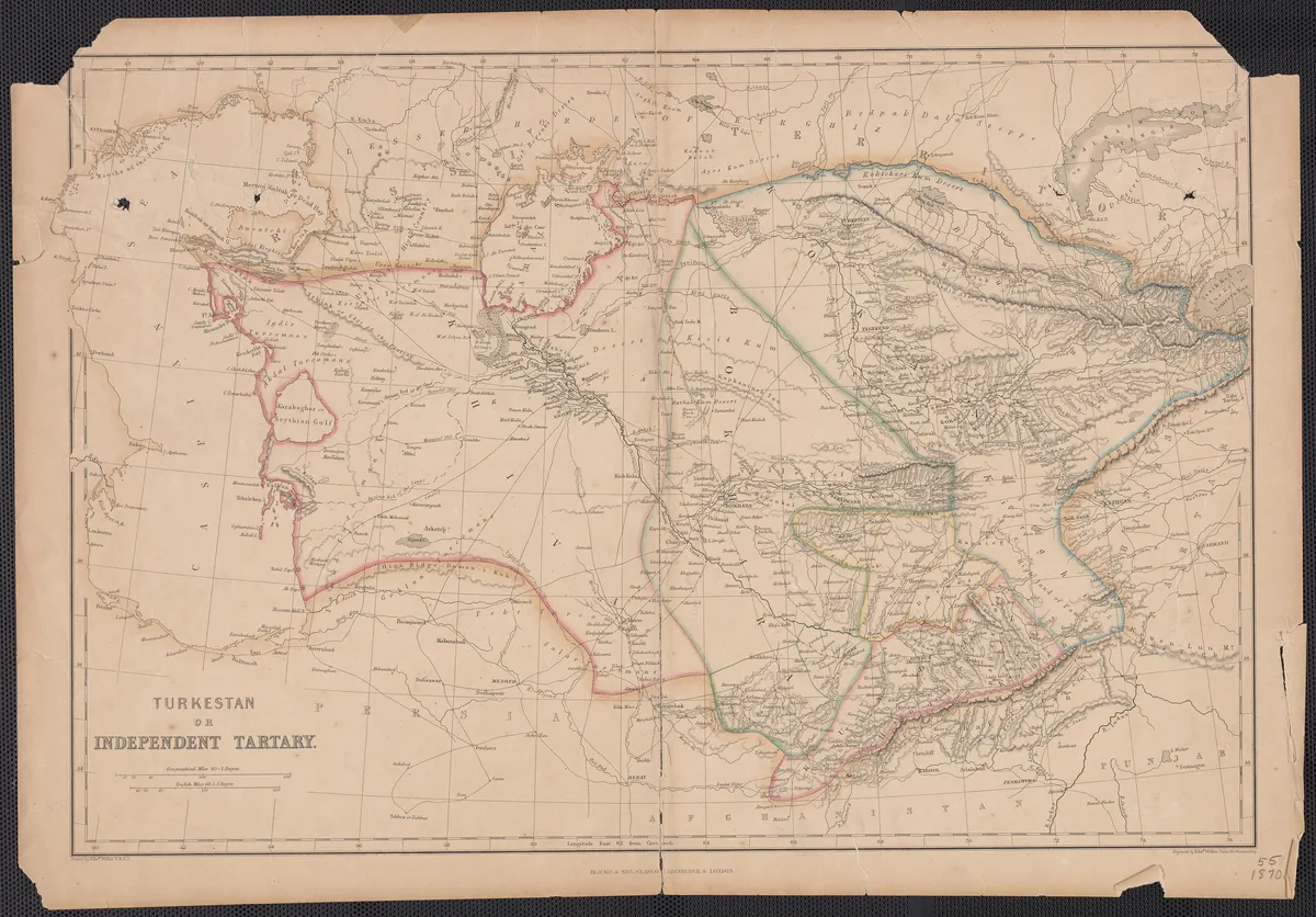
The name went slowly. Blackie's atlas sheet of the 1860s carries both words in one title, Turkestan or Independent Tartary. By Colton's Central Asia of 1885 the large lettering reads Russian lands, Turkestan, Afghanistan, Chinese Empire. Gorshenina finds it in literature into the 1930s, Peter Fleming's News from Tartary among the last, long after the scholars had dropped it.
It also stayed on the charts. The International Hydrographic Organization's list of the world's seas, in its 1953 edition, names a Gulf of Tartary between Sakhalin and the mainland. The American committee on undersea names lists a Tartary Trough. The gazetteers give the Russian form as Tatarskiy Proliv. Which leaves the name of the largest thing on the old maps of Asia lying on a strip of cold water.
The forums are still at work, and so are the map historians: the Library of Congress followed the word across its own sheets as recently as 2025. Most of the record leans one way: the same volumes that hold the big number say whose land it was.
The flag is smaller, and harder to put down. The 1694 and 1705 editions of Allard can be laid side by side. That would show when the Tartar flags entered the book, though not who, if anyone, ever flew them. A yellow field. A black owl. The dealers at Geographicus know of no reference to it outside the copies of Allard's plates.
The chart-maker of the French navy printed it in 1756 and declined to vouch for it.
Questions This Leaves You With
Is there anything a person actually does with this?
Nothing in your own life follows from it, and anyone charging you for the answer is selling something. What you can do is smaller and better. You can open the 1771 volumes, which are free to read, find the row, read the column heading, then look up Tobolski and Siberia. If the third digit looks like a 6 in the scan, add up the Asia column against the printed total on page 682. It takes ten minutes. The larger question stays with you: how a whole culture checks what it thinks it knows.
Does this sit against a religious account of the world?
Barely, though there is a thread. Ortelius put the Danites and Nephthalites on his sheet, and beside them he placed Arsareth, a name out of the book of Esdras, reading the lost tribes of Israel into the far north of Asia. A reader of faith can see an old hope that nothing promised is ever lost. A reader without it can see a scholar placing a text he trusted on land nobody he knew had crossed. People have held both. This site will not tell you which way that falls.
Does this change what a human life is?
Think of the people the name covered: Tatars, Bashkirs, Calmucs, Usbecs, Tibetans, whose descendants are alive today. For centuries a far-off printer's word sat over their lives, and most of them never knew it was there. One reaction is that a whole life can be filed under someone else's label, and that is a chilling thing. The other is that the label never touched what mattered. You may already know which one you had.
What would change your mind, in either direction?
Name it now, before you are committed. Toward a single state: a treaty or a coin naming Tartary as one power over the whole of northern Asia, an embassy from it recorded on arrival at a European court, a ship under that flag entered in a port's books. Away from it: an earlier source showing the flags began as a printer's plate, or a Russian or Qing record that accounts for the same ground year by year with no gap for such a state. A map on its own would not move it either way. Decide what would, and write it down.
Who drew the owl?
This is the open problem. The dragon has guesses attached, Kazan or the Crimea or Siberia. Flags of the World and the dealers offer none for the owl. Somebody chose that bird, for reasons nobody has recorded, and later sheets copied the choice. It may have stood for something real, in a port or a court, or it may have filled a space on a plate. The space where its explanation should be is still empty, and the books that might fill it can be opened.
Sources
- Tartariae sive Magni Chami Regni typus, in Theatrum Orbis Terrarum, 1570 Abraham Ortelius; Library of Congress Primary record
- Tartaria sive Magni Chami Imperium, Theatrum Orbis Terrarum, 1570, p. 47 Abraham Ortelius; Library of Congress Primary record
- Encyclopaedia Britannica, first edition, 1771: GEOGRAPHY vol. II pp. 682-684; TARTARY vol. III p. 887; TOBOLSKI and SIBERIA vol. III National Library of Scotland, via Internet Archive Primary record
- Tartary - an Empire hidden in history, stolenhistory.org, April 2018, Wayback capture KorbenDallas, forum thread Primary record
- Tableau des Pavillons, 1756 Jacques-Nicolas Bellin, Depot de la Marine; Wikimedia Commons Primary record
- Tartaria, plate of the 1606 atlas Jodocus Hondius; National Library of Israel Primary record
- Tartaria sive Magni Chami Imperium, Atlas Maior, 1667 Joan Blaeu; British Library Primary record
- Carte de Tartarie, Amsterdam, 1757, after the 1706 map Guillaume De L'Isle; Library of Congress Primary record
- Nicolaas Witsen and his contacts with the Russian Empire, Acta Slavica Iaponica 24 Tjeerd de Graaf and Bruno Naarden Study
- Vsya pravda o Tartarii, 5 October 2020 Raisa Khanukaeva, Russian Geographical Society Study
- Izobretenie koncepta Srednej/Central'noj Azii, 2019 Svetlana Gorshenina, Central Asia Program, George Washington University Study
- Inside the wild architecture conspiracy theory gaining traction online, 14 January 2022 Josie Adams, The Spinoff Study
- Skeptoid episode 765, 2 February 2021 Brian Dunning Study
- The Limits of Tartary: Manchuria in Imperial and National Geographies, Journal of Asian Studies 59(3), 2000 Mark C. Elliott Study
- Tracking Tartary on Western Maps, 20 June 2025 Amelia Raines, Library of Congress Study
- Atlas Geographus, vol. III, 1712, preface p. iv and p. 420 Herman Moll; Wellcome Library Primary record
- Nieuwe Hollandse Scheeps-Bouw, 1695 reprint, Royal Library The Hague copy Carel Allard Primary record
- Tartary flags, Flags of the World Flags of the World contributors General reference
- Bellin, Tableau des Pavillons, dealer note Kevin J. Brown, Geographicus General reference
- TARTARIE, Encyclopedie, vol. XV Louis de Jaucourt, via Wikisource Primary record
- The Journey of William of Rubruck, transl. Rockhill 1900 William of Rubruck; Silk Road Seattle, University of Washington Primary record
- Chronica Majora, vol. IV, ed. Luard, entry for 1240, p. 76 Matthew Paris Primary record
- The Travels of Marco Polo, Book I, Yule's notes Henry Yule, ed. Study
- Turkestan or Independent Tartary, 1860s W. G. Blackie; Wikimedia Commons Primary record
- Central Asia: Afghanistan and her Relation to British and Russian Territories, 1885 G. W. and C. B. Colton; Library of Congress Primary record
- Gulf of Tatary, Marine Regions record 4308, citing IHO S-23, 1953 VLIZ, Marine Regions Study
- Tatar Trough, Marine Regions record 6586 VLIZ, Marine Regions Study
- Qashliq Wikipedia General reference
- Tobolsk Encyclopaedia Britannica General reference
- Tatarskiy Proliv, SeaVoX gazetteer NERC Study