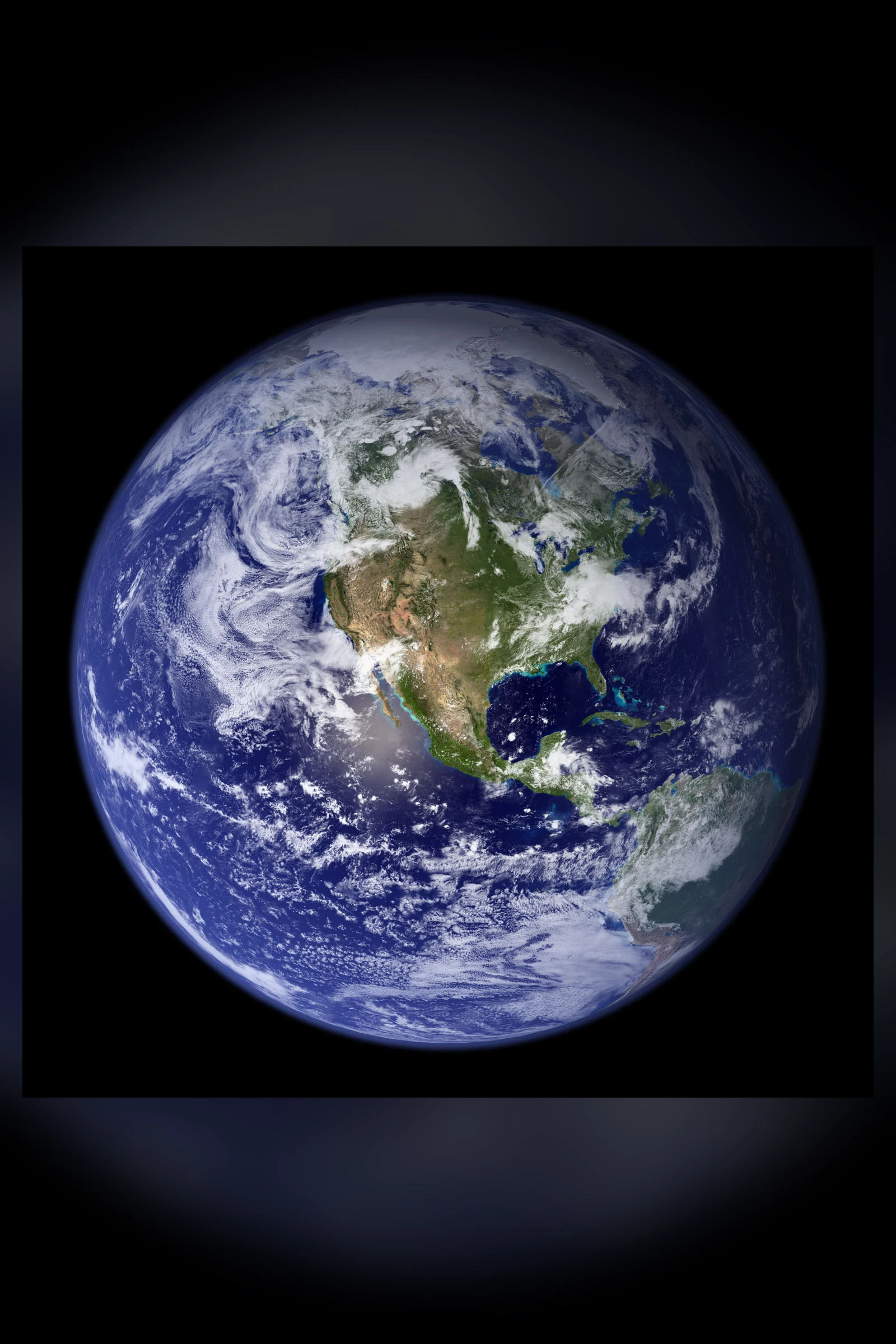
The charge is that every NASA picture of the whole Earth is computer-generated. Eric Dubay put it in print in 2015. His book calls the satellite pictures "clearly CGI and not photographs", and says "no real satellite photographs of the supposed ball Earth exist."
It has a witness on the inside. Robert Simmon worked at NASA's Goddard Space Flight Center, and in 2002 he helped make the Earth that went round the world. Months of satellite swaths became one seamless ball. The land came from one set of data, the clouds from another, and Antarctica, by his own account, "was pasted into the original from a different dataset".
Then came a line that the charge has been quoting ever since. Readers had noticed something in the clouds: shapes that came back, the same ones, in different places. In 2011, on a NASA blog, Simmon answered them in two words.
"They are."
A Picture That Was Not a Photograph
The image he was writing about is the 2002 Blue Marble. Apple later put a version of it on the iPhone. "It isn't actually a photograph of earth," David Yanofsky wrote in Quartz. "And that blackness surrounding it? That's not space, either." NPR's Science Friday had said it plainly in 2012: "It is not a photograph at all."
Simmon's blog sets out how it was made. The ocean was built from chlorophyll data and "colored" blue and green. Near the poles, "I just replaced missing data near the poles with white". The cloud repeats had a cause too: "There are gaps between orbits near the equator, and there's no way to fill them with real data." That is the sentence after "They are."
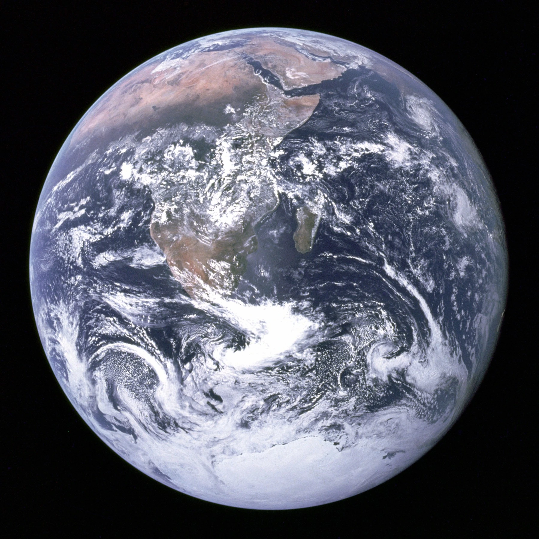
NASA's own profile of him adds a harder line. "The last time anyone took a photograph from above low Earth orbit that showed an entire hemisphere (one side of a globe) was in 1972 during Apollo 17." Quartz reported him saying NASA's Earth-observing satellites were too close "to see a full hemisphere". As a statement about anyone, that goes too far: Soviet cameras and the weather satellites below say so. As a statement about NASA's own cameras, from 1972 to EPIC in 2015, the charge is entitled to it.
The Charge, Finding by Finding
Dubay's proofs 171 to 178 are the fullest written form of the case, and others have added to it.
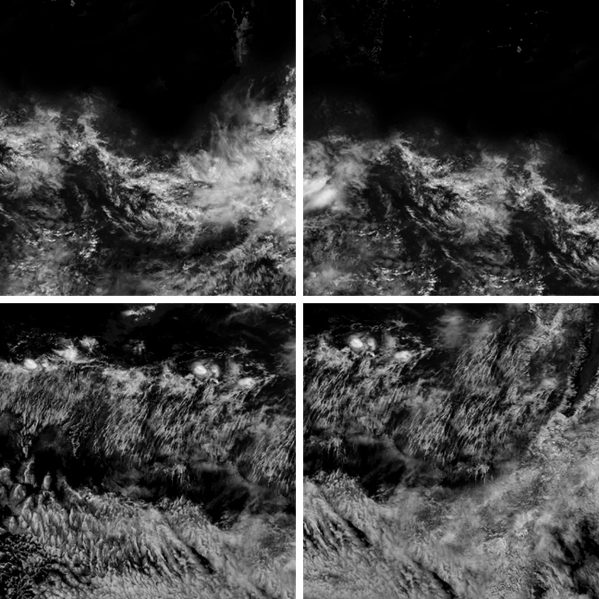
The clouds come first. Proof 173 says duplicate patterns are "solid proof that the clouds were copied and pasted in a computer program". On the 2002 map, that is what happened, and it can still be seen. Official X searched NASA's published cloud map for repeats and found them: one bank over Sudan and Chad sits twice, about 770 kilometres apart, and another does the same in the eastern Pacific, about 790 apart.
The continents do not hold still. Proof 176 says the "relative size of the continents" changes so much between pictures as "to prove beyond any reasonable doubt that the pictures are all fake". Set the 2002 ball beside Apollo 17's and North America looks a different size.
The edges give the game away. Proof 175 says analysts found "rectangular cuts found in the black background" around Earth once brightness and contrast are pushed. The clouds spell things: proof 174 says NASA artists placed "the word 'SEX'" in them, a charge first made in 2015 over a frame from NASA's EPIC camera turned upside down.
The word composite itself sits in NASA's captions. "As soon as you start looking into the pictures of the globe, you start seeing words like 'composite' or 'animation'," Rob Skiba told ABC News in 2018. He was right about the captions. NASA calls its 2012 Blue Marble a montage. Weather satellites do not take snapshots either: Japan's Himawari sweeps the disk in about ten minutes, and the US GOES has no green band, so its green is calculated. EPIC builds each colour picture from three exposures.
And Apollo itself is on the list. Proof 177, from the film-maker Bart Sibrel, says the crew of Apollo 11 faked a round Earth with "a round window in their dark cabin". In 2021 a journal paper called one Apollo 17 picture, with Earth in its sky, a composite. The journal retracted it. The authors did not agree.
If Every Picture Is Made
Set aside for a moment whether it is true. Ask what it would mean.
It would mean that the single most reproduced image of our home was never seen by anyone. Every school wall, every phone and every book cover would carry a drawing, and we would have grown up mistaking an illustration for a record.
It would mean that the feeling astronauts came back to describe, and that a generation took from one blue picture, rested on an artist's choices about blue. Whole movements have been built on that image. They would have been built on a design.
It would mean that the weather forecast on the morning news, the typhoon track, the hurricane warning that moves a city, were resting on pictures nobody outside a few agencies could vouch for. We would be taking the sky on trust from the same institutions that told us it was theirs to explain.
It would mean that the strangers who first spotted the repeating clouds were the only honest readers the picture ever had. Every correction we have ever had on the subject would have come from outside, from people with no budget, and the rest of us would owe them something.
It would mean that the most basic thing we think we know about our own position, what the world looks like from outside, is known to us the way a rumour is known. If that much could be painted and handed down, then the honest position for all of us would be to start again, from whatever we can check ourselves. And the first question would be how much of that there is.
What the Findings Come To
Some of the charge stands, and it stands on the maker's own words: the clouds, the ocean colour, Antarctica, the word composite. Those are one image, or one family of images, and they are admitted.
The other findings come out differently. Continents change size because a sphere does: an eye near the Earth sees about a third of it, an eye a million miles out nearly half, and a desk globe shows the same thing. NASA gave its 2012 viewpoint as 7,918 miles up. Full Fact tested the rectangles and found them only in low-quality copies. Official X found no study that tested all the pictures. Dubay does not name his analysts. A claimed admission by the astronaut Nicole Stott could not be traced. The Flat Earth Society's wiki takes a different line from Dubay: "NASA is not hiding the shape of the earth from anyone."
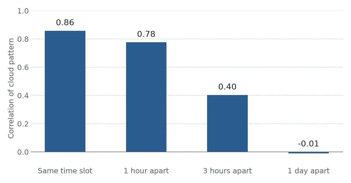
So Official X ran the test. Frames from separate nations, same time slot, on 31 October 2026, compared cloud for cloud. Russia's Elektro-L No. 4 hangs over the Pacific at 165.8 degrees east. Japan's Himawari-9 sits at 140.7. The US GOES-18 sits at 137 west. Each frame was mapped to the ground, and the cloud patterns correlated. Russian against Japanese, same slot: 0.86. One hour apart: 0.78. Three hours: 0.40. One day apart: zero. GOES against Himawari, same slot: 0.61, and zero a day apart. In a separate run, a NASA EPIC frame from 29 October against Himawari gave 0.58, and 0.03 a day apart. China's FY-4B, at night, gave 0.41 and 0.03.
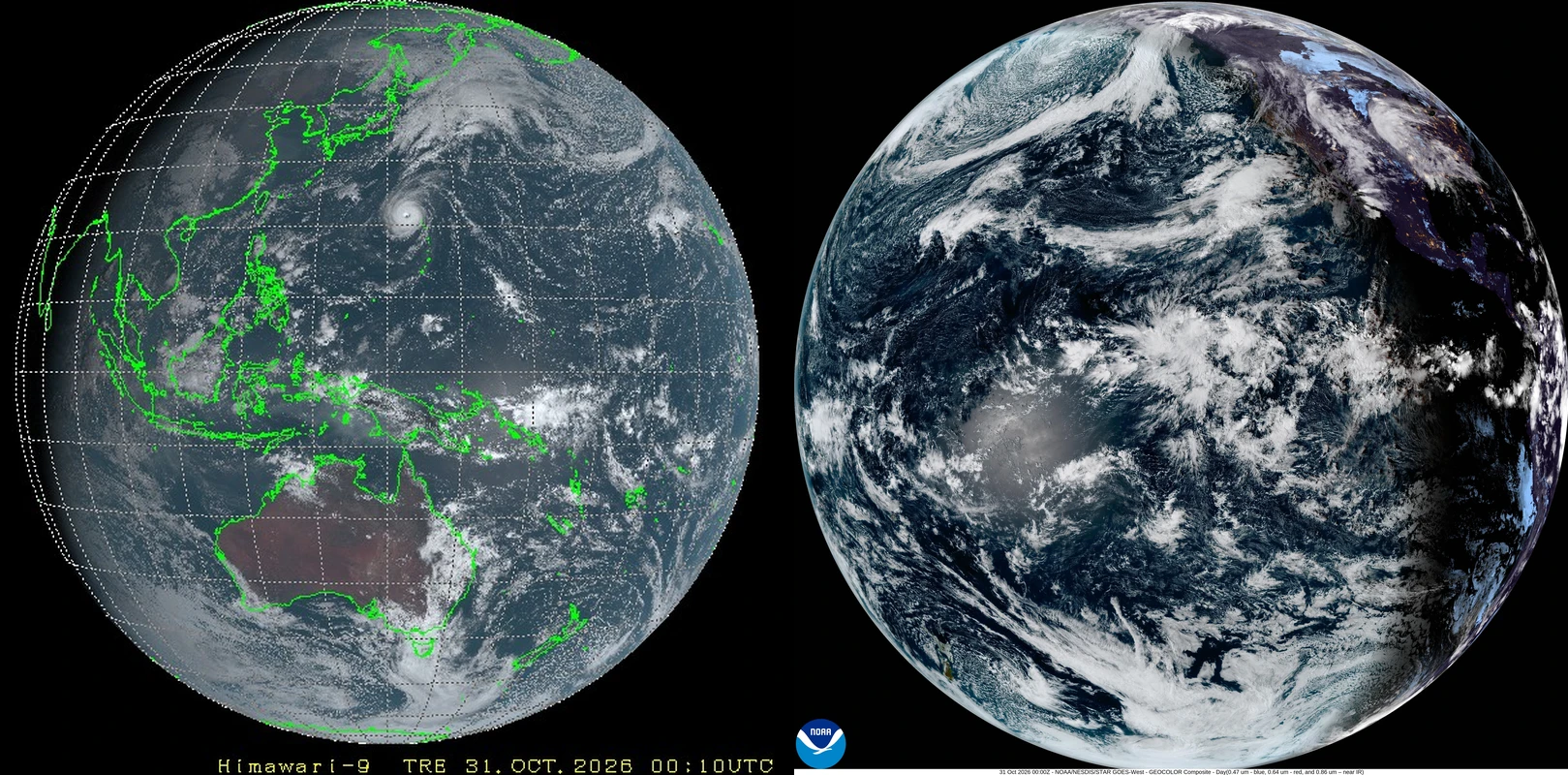
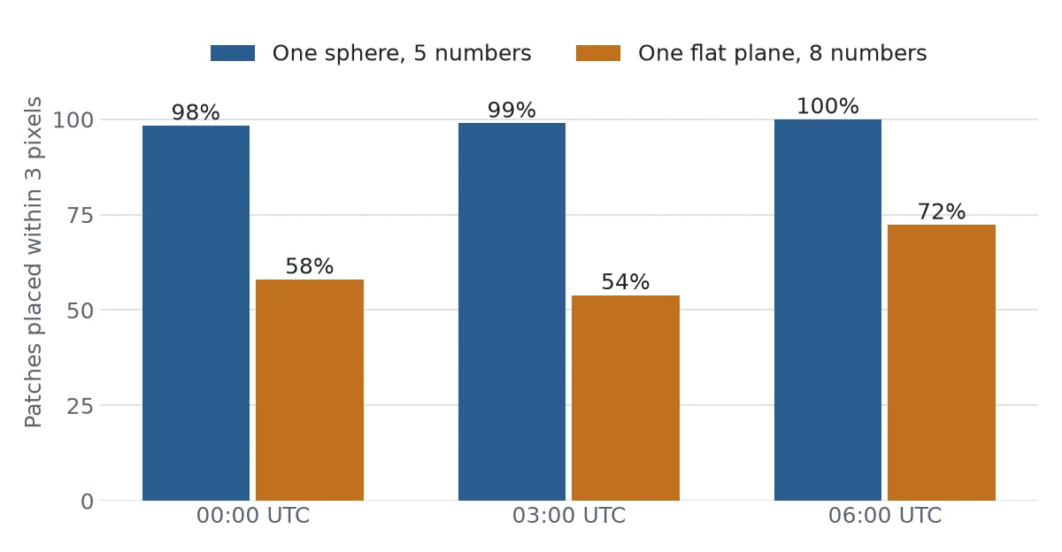
Then the shape. Two pinhole cameras looking at one flat surface must be related by a single plane mapping, whatever their height or angle. So cloud patches were matched between the Japanese and Russian frames by searching the whole frame, with no model choosing the matches, and the 181 that matched were put to both. A sphere, with five fitted numbers, placed 178 of them within 3 pixels, about 50 kilometres. A flat plane, with eight, placed 105. The sphere's fit also put Elektro within a third of a degree of its published longitude. Two more frames, three and six hours later, gave the same order: 189 against 103 of 191, and 141 against 102 of 141.
What That Does Not Reach
Every frame in that test came from a government server, not a dish. They are processed products, built from scans, by agencies whose engineers talk to each other. They are rivals in politics and colleagues in meteorology. The 0.86 is also a best fit: the Russian frame's centre, tilt and longitude were searched against the Japanese one over some 1,600 combinations. A separate run that allowed only a small shift gave 0.65, against 0.06 for the control. Elektro's clock is inferred from the fit, and each scan takes minutes. A theory that held all of them in one shared model would survive this test, at the price of Russia, China, Japan, Europe and the United States all rendering the same sky live, every ten minutes.
The test covers a few frames from one week of 2026. It says nothing about 1972. Official X found no independent cloud match for the Apollo 17 picture, and the film itself is held by NASA. The picture has had readers: a Spanish meteorologist read its weather systems in 2020. That is not the same as a Soviet satellite's frame of the same hour. Earth's whole-disk record outside NASA does reach back, to a Soviet camera in 1966 and to Zond 7's film, returned to the USSR in 1969. Those are states too.
A flat earth advocate has fair objections to the plane test. The frames are agency products, already resampled by people who assume a ball. These instruments are scanners, not cameras, and the conversion used here assumes the Earth's angular size. Clouds are not at ground level. And no flat earth author proposes a plane under two pinhole cameras 36,000 kilometres up. The test rules out that one arrangement, on these frames. It does not rule out every geometry anyone could propose. The SEX reading was never tested against another satellite. "It's photoshopped because it has to be", the line most often pinned on Simmon, is in none of the texts Official X read, including the Quartz piece it is usually credited to; it circulates as the title of short videos. The journal gave no detail beyond "serious concerns" when it retracted the Apollo paper. Artemis II's Hello, World picture of April 2026 has not been checked against a weather satellite.
Official X found no picture of a whole hemisphere with no state anywhere in the chain. Israel's Beresheet and China's Longjiang-2 come nearest: Longjiang-2 was a student camera at the Moon, and radio amateurs in Germany, the Netherlands and Latvia helped bring its data home.
The Dish on the Roof
In the frames tested, the word all does not survive. A NASA frame from this month shows the clouds Japan shows, and the frames of one time slot fit one sphere better than one plane. The charge is right about the picture that made it famous, and Official X found no evidence for it in the frames it could test.
What it has left is more interesting. The Blue Marble taught the public to treat a composite as a photograph, and nobody on the iPhone said otherwise. The people who first spotted the clouds were right before NASA said so. Whoever they were, no record Official X found names them.
And the gap they were pointing at is real. Almost nobody can check any of this from home. Elektro-L's signal comes down in the clear, and a small dish can catch it. Official X found no published comparison of a frame taken down that way with the same slot on the agencies' servers. Until someone runs one, every frame in this article has come through the hands it was asked to check.
Questions This Leaves You With
Is there anything you actually do with this?
Mostly, you read captions. The word composite is not a confession and it is not a nothing: it tells you the picture was assembled, and from what. A photograph, a scan and a render can all be honest, as long as nobody is calling one the other. If you want to do more, every source in this article has a public address, and the Downloads section holds the method. The frames for any minute are free. Anyone who says something about these pictures, in either direction, can be asked to run it.
Does this sit against a religious account of the world?
Some of the people who hold this charge hold it for religious reasons, and others hold the picture itself as close to sacred: an image of one small home. Neither is what the test measures. A cloud match says what two machines recorded at one minute. It does not say what the world is for, or who made it, or what any scripture requires. Official X will not tell you how that falls. People in every tradition have looked at the same Earth and drawn different meanings from it.
Do you need to rethink anything?
Set your own life against the picture. The one on your phone was built by a small team, and they filled the gaps by hand. That can feel like a betrayal. It can also feel like something closer to the truth about most of what you know: assembled by someone, from partial records, and good enough until checked. You rely on that kind of knowledge every day. The clouds over your head this morning are in a Russian frame and a Japanese frame, and neither agency asked your opinion of them.
What would change your mind, in either direction?
Name it first. If you hold that every picture is made: a frame you received yourself that matches the published one to the cloud would be hard to get round. If you hold that the pictures are records: a rival agency showing different clouds in the same time slot would be a serious problem, and so would a home reception that differed from the published frame. So would proof that the Apollo 17 clouds match no record of that day. Each of those can be looked for, and none of them has been found.
Why does the word photograph matter so much?
That is the part still open. Nobody disputes that a weather map is useful, and hardly anyone gets angry about a painting of a ship. The anger starts when something made is taken for something seen. Agencies had good reasons to make the Blue Marble, and it was captioned, in the small print. But the picture travelled without the caption, onto phones. Whether the public was misled, or just never told, is not a question any satellite can answer.
Downloads
- The satellite comparison: method, scripts, matched clouds and results, 2026Official X. Third-party frames are not included; the file lists where to get them
Sources
- The satellite comparison: method, scripts, matched clouds and results, 2026 Official X. Third-party frames are not included; the file lists where to get them Primary record
- Crafting the Blue Marble, 2011 Robert Simmon; NASA Earth Observatory Primary record
- Blue Marble clouds, 2002, the 8192 pixel map NASA Visible Earth Primary record
- Robert Simmon, aka Mr. Blue Marble NASA Primary record
- The guy who created iPhone's Earth image explains why he needed to fake it, 2014 David Yanofsky, Quartz Study
- Science Friday, 3 February 2012, transcript NPR Primary record
- Eric Dubay's 200 Proofs, quoted in full flatearth.ws Study
- Inside the Flat Earth International Conference, 2018 ABC News Study
- Earth by Suomi NPP NASA Primary record
- Blue Marble 2012 caption NASA, via EurekAlert Primary record
- Advanced Himawari Imager Japan Meteorological Agency Primary record
- Explained: It's photoshopped because it has to be, 2019 Mick West, Metabunk Study
- From a Million Miles Away, NASA Camera Shows Moon Crossing Face of Earth, 2015 NASA Primary record
- Finding SEX on NASA's EPIC Earth image, 2015, repost The Coincidence Theorist, via Free Republic Study
- A Funny Thing Happened on the Way to the Moon Wikipedia General reference
- Interpreting Locked Photographic Data: The Case of Apollo 17 Photo GPN-2000-00113, 2021 Pyrrhon Amathes and Paul Christodoulides, Designs 5(1), 8; repository record Study
- Retraction notice, Designs 5(1), 21, 2021 MDPI Primary record
- NASA did not photoshop Apollo images, 2021 Tom Norton, Full Fact Study
- NASA, The Conspiracy The Flat Earth Society wiki Study
- Elektro-L4 RussianSpaceWeb Study
- Elektro-L No. 4 images, the last 24 hours NTsOMZ, Roscosmos Primary record
- Himawari real-time images NICT Primary record
- GOES-18 full disk GeoColor NOAA Primary record
- Weather reading of the Blue Marble, Weather 75(11), 2020 Sergi Gonzalez Herrero; AEMET repository Study
- Christie's lot with UPI caption on Molniya-1, 1966 Christie's Study
- Zond 7 image of Earth The Planetary Society Study
- Hello, World (photograph) Wikipedia General reference
- Beresheet selfie with Earth The Planetary Society Study
- Imaging the Earth from lunar orbit Daniel Estevez and others, The Planetary Society Study
- L-Band Weather Imagery Soon Coming Back to Western Europe via Elektro-L3, 2026 RTL-SDR.com Study