
The mud flood is the claim that the ground floors of the old cities were buried, not long ago, by a disaster nobody wrote down. Its best picture was taken in 2001, under the sidewalk of J Street in Sacramento, California.
A brick vault curves overhead, its surface flaking away in scales. Under the vault stands a wall of old brick, and in the wall are a tall doorway, boarded and dark, and a narrow window with a thin line of light behind the glass. Rubbish lies across the floor. A pipe runs straight across the doorway at the height of a man's head.
This is not a cellar. It is the front of a shop. The building's own survey calls it the store front, and says a man named Anthony Coolot sold from this floor, at the level of the street.
The street ran above the ceiling.
Nobody looking at that door can call it a basement window. The shop is real, and it went underground.
The Notions Dealer of 812 J Street
The photograph is number 10 in a federal record, the Historic American Buildings Survey, made by Ed Anderson. The survey tells the story of its owner in plain clerk's prose. Coolot came from Austria, sailed to California in 1854, tried the mines at Moore's Flat, and came back to Sacramento within six months with little more than his clothes. He sold stationery, schoolbooks, pocket knives, playing cards and cigars. In 1861 he married, bought his lot, and put up a modest brick building worth about $1,200, with iron shutters on the doors and windows at the street.
That winter the floods came.
The survey has no plans, no builder and no architect for the first building, and it gives both 1861 and 1863 as the date. What it does give is the sequence. His store became a basement, his family's floor became the shop, and he built a new storey on top. The building itself is gone, razed after a fire in 2003.
A thousand kilometres north, Seattle has the same picture on a larger scale. The Great Fire of 6 June 1889 burned the business district. Seattle's transportation department says engineers then raised Pioneer Square's streets a full story, and that architects provided for two "ground floors", the lower one under the new sidewalks. HistoryLink's account has the first and sometimes second stories below the new street, their storefront windows staring out at retaining walls.
The windows are real. So the question is who, or what, put the ground above them.
Stories Below the Street
The answer the theory gives started in Russian. A blog series called Where Did the City Come From?, in a chapter dated 2013, set out the puzzle at St Petersburg. The city was founded in 1703, yet engravings of 1716 already show a first floor in the ground. How long, it asked, must a building stand to sink that far? The author asked for someone to dig at the foundations.
Philipp Druzhinin tied it to a lost Great Tartaria and carried it into English by early 2017, with a video title that fixed the date as "the Mud flood of 19th century". On 5 April 2018 KorbenDallas, who that same month argued on Stolen History that Tartary was a country, gathered the examples into one post: the Winter Palace, Seattle, Spain, England, Denmark, the Czech Republic. He rejected the stock answers one by one, and he was frank about the rest: "we know nothing of what might have caused it."
Tartaria Britannica supplied a mechanism in 2023. Soil liquefaction, it wrote, is ground in which "material that is ordinarily solid behaves like a liquid", set off by earthquake or "frequency". Walking London, its reporter saw vault lights and sunken floors on the major roads and concluded that the flood there was "around 7-9 ft" deep and "clearly affected the whole city". Its star exhibit is St Mary Magdalene in Omaha, captioned 1908 after excavations, a church standing a full storey out of the ground. "Notice the window is now the door."
Then comes the hardest argument, and it is about labour. Who moves that much dirt, and why? Tartaria Britannica calls it "a gross misuse of materials and resources" in an age with no motorized ground-clearing machines. KorbenDallas puts it in numbers at Chattanooga: raising a city is "easier said than done", and hard to justify when the 1870 population was only 6,000.
Which leaves, on that reading, one event and many cities: low windows that look alike across continents and, where a date is given at all, a date near 1800 or after.
If the Ground Moved
Set aside for a moment whether it is true. Ask the larger question. What kind of world are we walking on if it is?
On that reading it would mean, first, that the sidewalk is a lid. Every old downtown would have a floor beneath it with its doors still on, and every city guide would be describing the wrong century.
It would mean, next, a catastrophe on a scale our species has never recorded, reaching Sacramento and St Petersburg in one stroke, and leaving no diary. We kept records of comets and bad harvests. If we missed this, then what we call the written record has a hole in it the size of the nineteenth century.
It would mean something harder about us. We would be the descendants of survivors who did not know they were survivors, walking in at the second floor and calling it the front door. Our sense of an unbroken past would rest on nothing but the habit of not looking down.
And one consequence is still in front of us. If ground can rise that fast and that quietly once, then nobody can say what would record it next time, or whether it would be believed.
Street by Street
The standard account holds that there is no one answer, because there is no one event, and that each address has its own dated cause.
In Sacramento the city raised its streets after the floods of 1861-62. The Central City guide describes a 13-year process from 1864 to 1877, with brick walls about ten feet high beside the road and fill between them; bridging the gap was left to business owners. The figures differ by source and block, from about ten feet at 812 J to 12 to 15 in the state park plan. In Seattle the council passed the ordinances on 21 June 1889, 15 days after the fire. In Chicago, Ellis Chesbrough's sewer report of 1855 asked for an average of eighteen inches; by spring 1856 he wanted six to ten feet. Galveston, after the storm of 1900, pumped in sand from a dredged canal. The American Society of Civil Engineers counts 16.3 million cubic yards, up to about eleven feet deep. St Patrick's Church, 3,000 tons, rose five feet on 700 jacks. On this account the question about labour has its answer: the dirt is on the invoice.
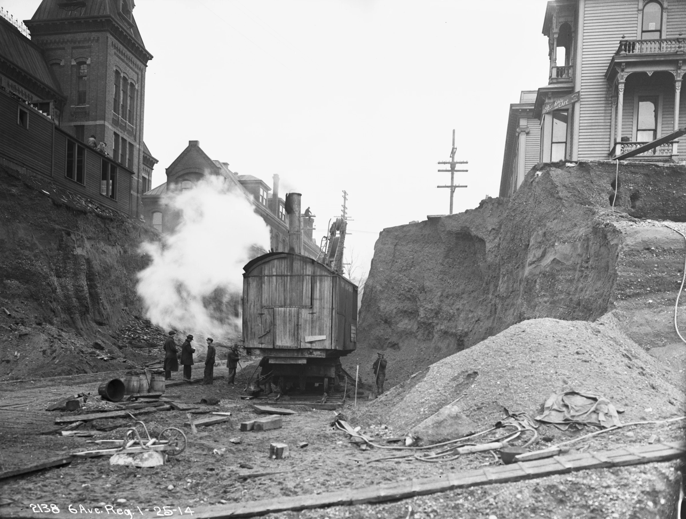
Omaha runs the other way in its custodian's account. History Nebraska dates the matching view to May 1920. The city lowered Dodge Street by twenty feet, and the lower level was built new beneath the church.
Prague's ground rose through the 1200s as the Old Town was laid out, and its excavators find the lower storeys were partly dug in from the start. And St Petersburg has been dug. O. V. Andreeva and E. A. Sharova published a section at the Gosudarev Bastion of the Peter and Paul Fortress: lower windows walled up in 1837, the original threshold at 2.08 metres, the modern surface at 3.60, cultural deposits of about 1.6 metres. Windows at the ground, in the city of the puzzle, with a year on them.
From the 1200s to 1920. That is the span of the dates on these buried floors.
Mud That Really Fell
None of that reaches everything. The standard account covers the addresses it has records for.
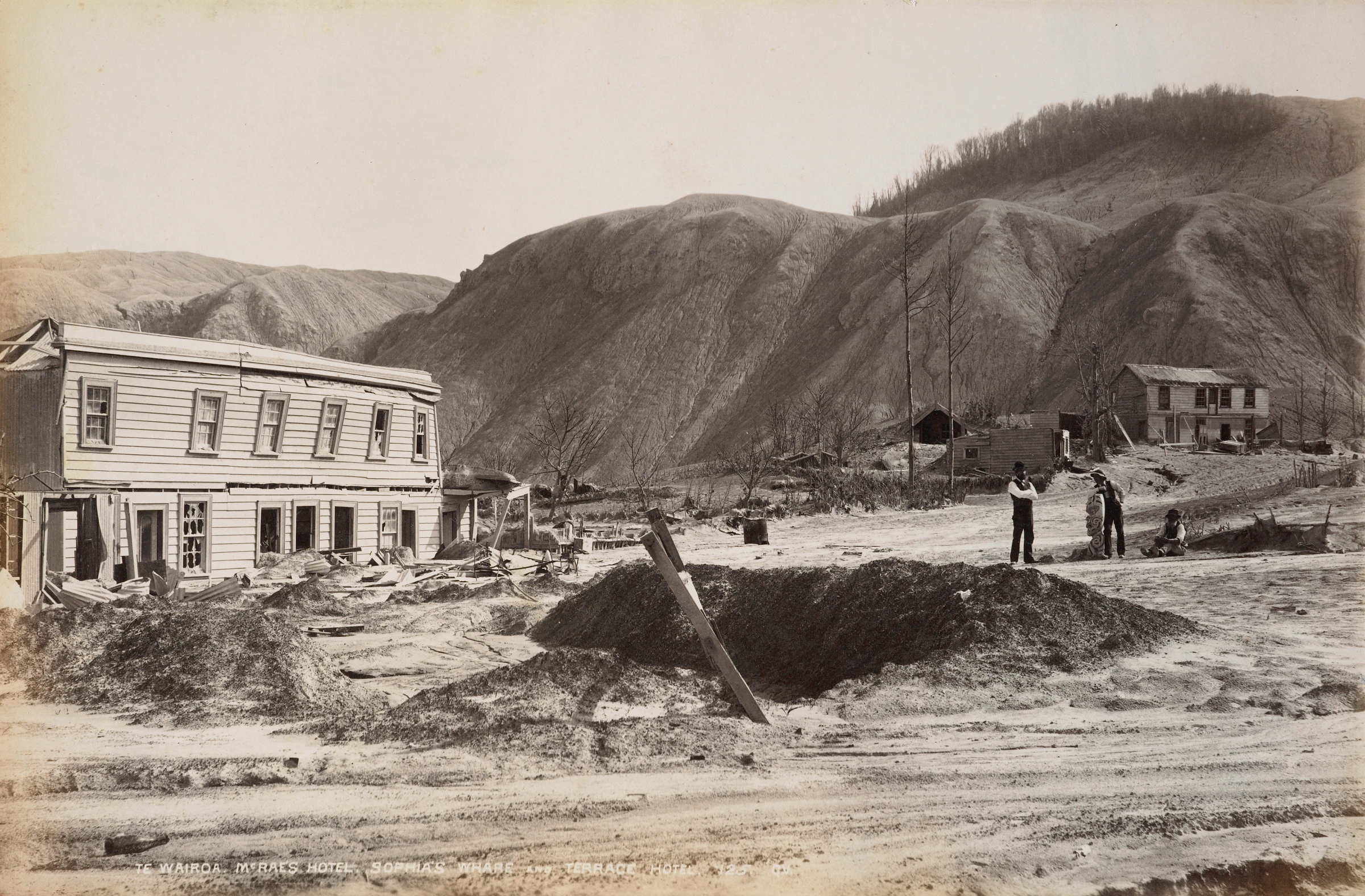
Ground does swallow buildings. At Te Wairoa in New Zealand the eruption of Tarawera on 10 June 1886 left nearly 2.5 metres of ash, mud and debris, and the surveyor S. Percy Smith recorded a heavy rain "charged with mud". That is a real mud fall in the right decade, and George Valentine's photograph of that year shows a trench dug through it. It stopped at the district.
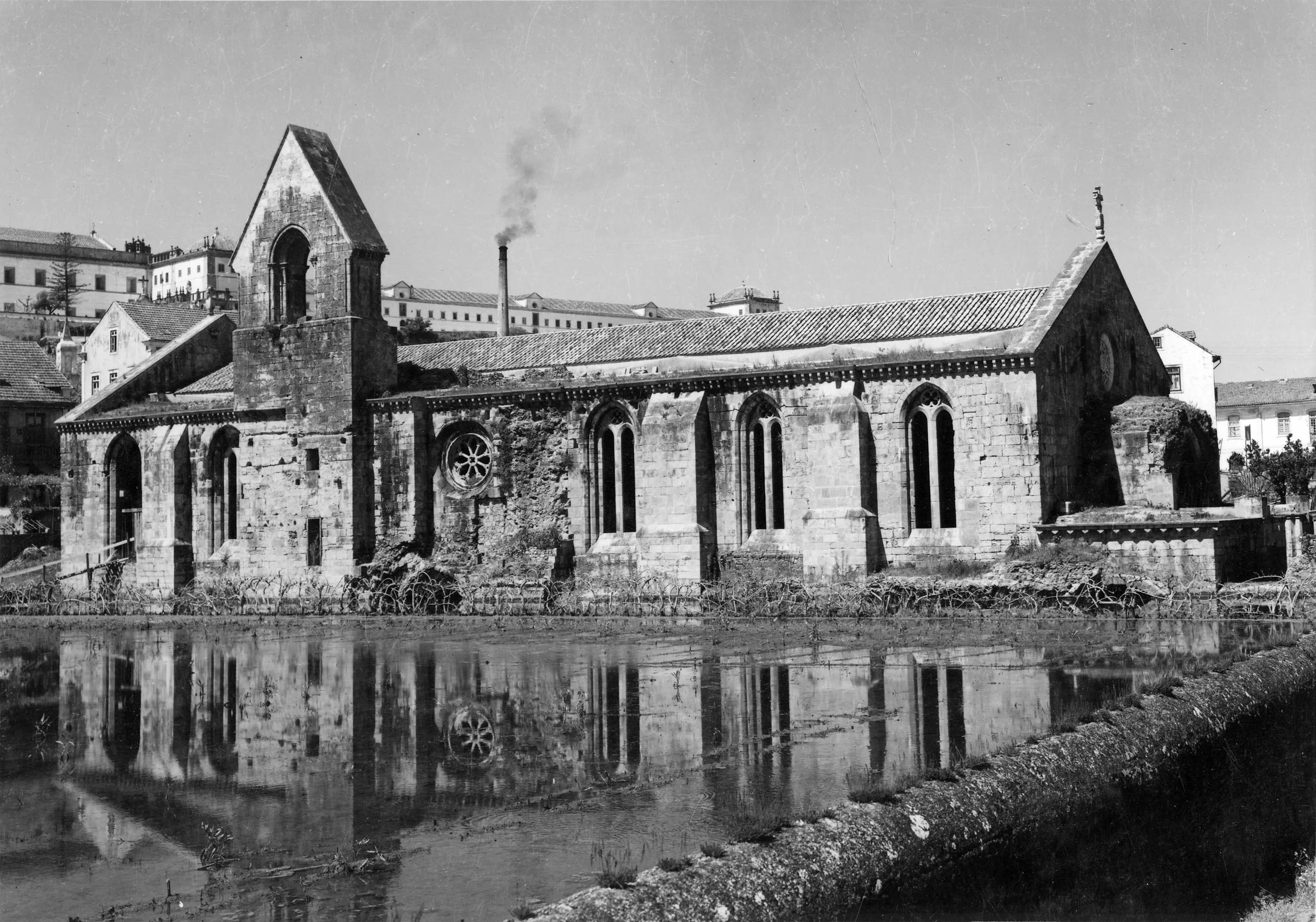
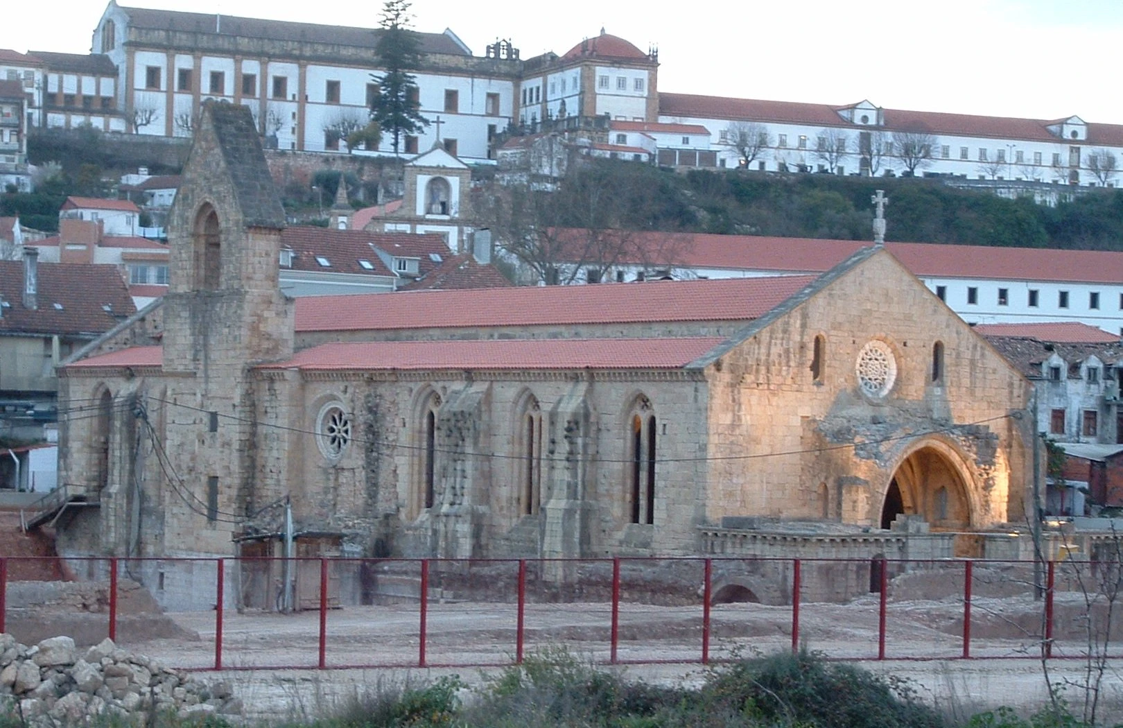
At Santa Clara-a-Velha in Coimbra, Portugal, the church consecrated in 1330 met the flooding Mondego the very next year. The nuns raised the floor again and again, added an upper storey, and left in 1677. River sediment took the rest. Excavation from 1995 to 2000, with constant pumping, found the lower church. In a photograph of about 1954 its windows stand close above a sheet of water. That is a storey lost to a river, over some 350 years.
At Edfu in Egypt, Felix Teynard photographed the temple court in 1851 with debris heaped against the reliefs. Gustave Le Gray photographed it in 1867 with the court cleared and the carved panels bare. Auguste Mariette, who ran the clearance, describes a village on the roof and rooms full of rubbish, and says nothing of mud.
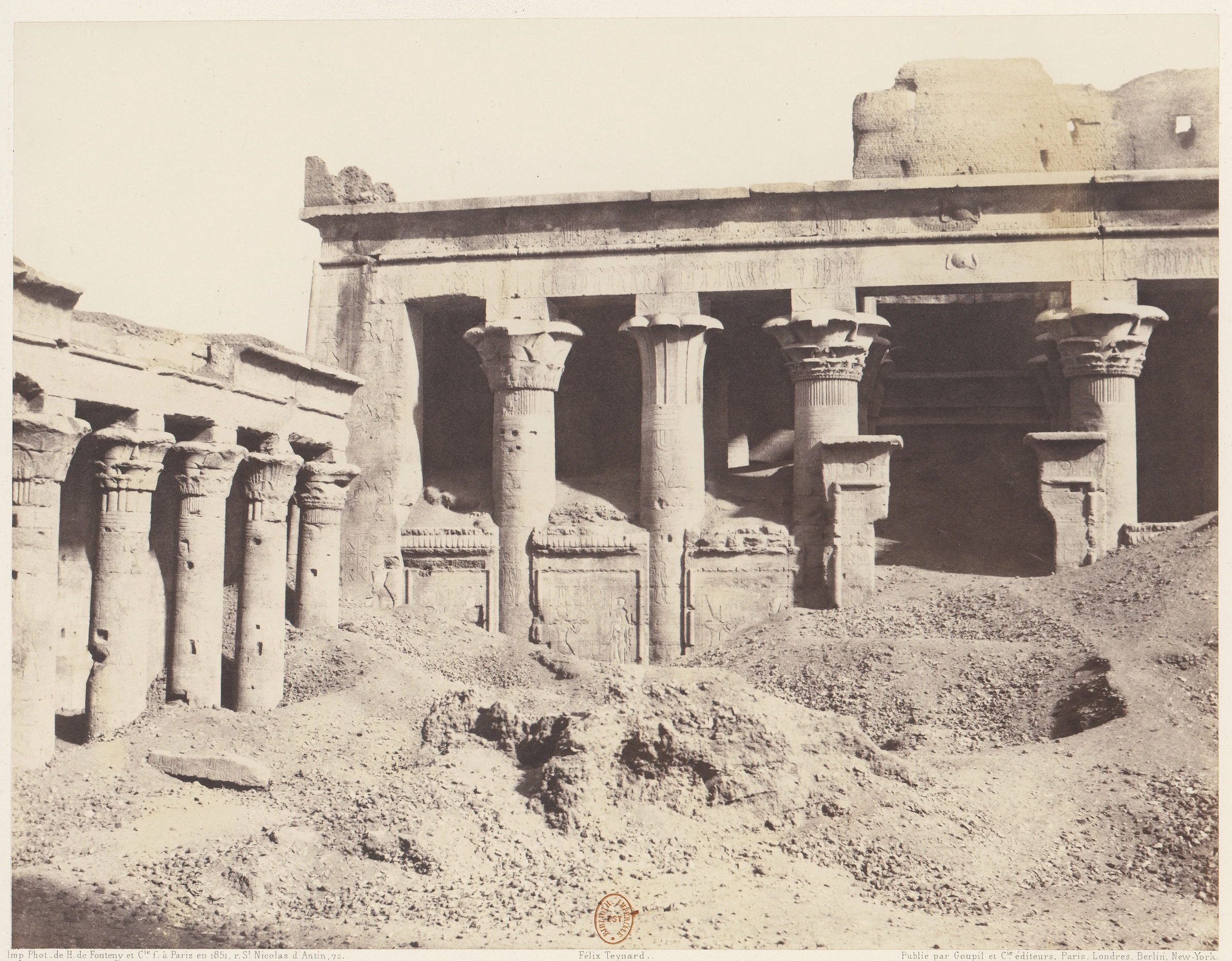
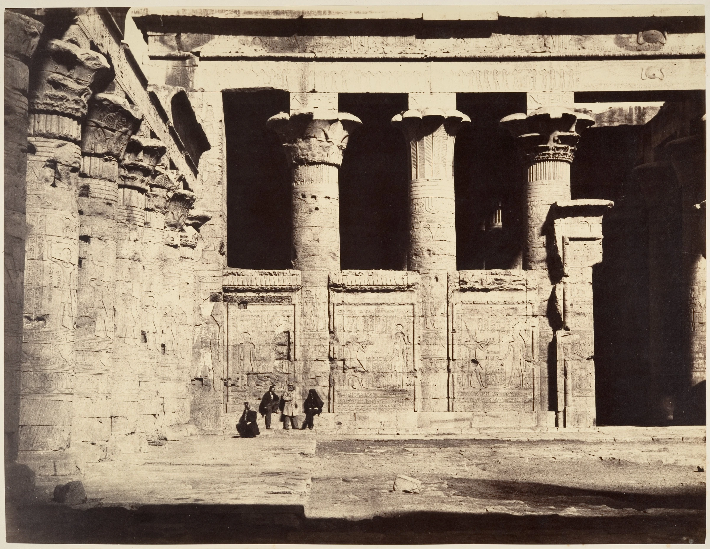
And Sacramento has real mud of its own. G. K. Gilbert of the US Geological Survey measured more than 13 feet of mining debris in the river channel there, part of 1.3 billion cubic yards washed out of the Sierra.
So burial is real, and it is dated, and it differs from place to place. The proponent pages opened for this article give no measured section at a named address, no date for a deposit and no tie between two cities. A search of the critics turned up none either, and no excavation report came to light for the Winter Palace, the theory's first witness.
In these records, nobody found the layer.
The Door Under J Street
The question has become a test that either side could run. Cut a trench against a wall, at a named address, in two cities. Date what lies in it by its coins, pipes, pottery and tree rings. See whether the fill is tipped in bands against the wall, as a street contractor leaves it, or lies in one bedded unit that ran through the rooms, as at Te Wairoa. It could show that one address had a flood. It could not, from one trench, show the world did.
Until then the St Petersburg bastion stands as the nearest thing to the dig that the 2013 blog asked for. A threshold, a survey level, a year. That is one fortress wall, and the Winter Palace is not the bastion.
The building at 812 J Street is gone. One local history records a later sidewalk collapse there, and Official X could not confirm whether the old shop front survives or was lost with the rest. If it survives, a doorway from the 1860s is still standing in the dark, facing a brick wall, waiting on a customer.
The record says who moved the street. It is less sure who has checked the door.
Questions This Leaves You With
Is there anything a person actually does with this?
Nothing in your own life depends on it, and anyone selling a date for the next one is selling something. What you can do is walk your own downtown and pick one low window. Ask the city's archive for the street grade file and the building's oldest permit. Many cities keep them. You will learn more from one address than from a hundred photographs. The larger question is what a city remembers about its own ground, and how much of that memory anyone has ever checked. It stays with you.
Does this sit against a religious account of the world?
Some people in these threads reach for a flood as scripture tells it, and others want no scripture near it. Both can read the same window. A reader of faith may see in a buried doorway a reminder that human works are brief, and that needs no recent catastrophe to be true. A reader without faith may see only drainage. Serious people have argued about ancient floods for a long time. This site will not tell you which way that falls.
Does this change what a human life is?
Think about Anthony Coolot, who built a shop, watched the street rise past his doors, moved the shop upstairs and carried on for decades, until his death in 1900, one of the richest men in town by the assessor's rolls. One reaction is that a life's work can be under the pavement in ten years. The other is that he went on selling pocket knives, and his name is on the federal record. You may already know which one you had.
What would change your mind, in either direction?
Name it now, before you are committed. Toward one event: a single bedded deposit inside sealed rooms in two cities far apart, dated to the same decade by what lies in it. A diary, a ship's log or a newspaper from the week it happened. Away from it: a grade ordinance and a contractor's bill for the exact address you find strangest, or a trench at the Winter Palace showing fill tipped in by barrow. A photograph alone will not move it. A bill can be wrong and a trench can be misread, so the strongest answer would use both at one address, and a third record if it can be had. Decide what would.
Where is the layer?
This is the open problem. Archaeologists log these cities one trench at a time, in their own languages, for their own reasons, and no study laying those logs side by side turned up here. If something runs through them all, it has not been shown. If nothing does, that has not been shown either. The space between those two sentences is empty, and the trenches to fill it are already in the archives.
Downloads
- Historic American Buildings Survey, Coolot Building, 812 J Street, Sacramento, HABS No. CA-2726, written historical and descriptive data. US federal record; no rights statement in the fileNational Park Service; Library of Congress
- E. S. Chesbrough, Report and Plan of Sewerage for the City of Chicago, 1855. National Library of Medicine: believes this item to be in the public domainUS National Library of Medicine copy
- S. Percy Smith, The Eruption of Tarawera: A Report to the Surveyor-General, 1886. Internet Archive: not in copyrightCopy from the Internet Archive
- Auguste Mariette, The Monuments of Upper Egypt, 1877. Internet Archive: not in copyrightCopy from the Internet Archive
- G. K. Gilbert, Hydraulic-Mining Debris in the Sierra Nevada, USGS Professional Paper 105, 1917. US federal reportUS Geological Survey
Sources
- Historic American Buildings Survey, Coolot Building, 812 J Street, Sacramento, HABS No. CA-2726, written historical and descriptive data. US federal record; no rights statement in the file National Park Service; Library of Congress Primary record
- The original store front of Coolot's building, now underneath the sidewalk, HABS CAL,34-SAC,66-10, Ed Anderson, 2001 Library of Congress Primary record
- Hickman Coleman Insurance Company, Coolot Company, Comstock Building Nacht and Lewis Study
- National Register of Historic Places in Sacramento County: Coolot Company Building NoeHill General reference
- Work Down Under, 25 February 2010 Seattle Department of Transportation Primary record
- John Caldbick, HistoryLink essay 21099, 2020 HistoryLink Study
- Otkuda gorod? (Where Did the City Come From?), ch. 16, 2013 Blog Study
- Philipp Druzhinin channel, capture of 2 March 2017 Internet Archive Primary record
- KorbenDallas, Mud Flood, dirt rain, and the story of the buried buildings, 5 April 2018 Stolen History Primary record
- KorbenDallas, Mud flood in Chattanooga, 17 December 2018 (repost 2020) Stolen History Primary record
- Mudflood Theory Part I: Soil Liquefaction, 2023 Tartaria Britannica Primary record
- Mudflood Theory Part III: Theory or Fact?, 2023 Tartaria Britannica Primary record
- Central City Urban Design Guide, section 2, 2009 City of Sacramento Primary record
- Old Sacramento State Historic Park General Plan and EIR, June 2014 California State Parks Primary record
- E. S. Chesbrough, Report and Plan of Sewerage for the City of Chicago, 1855. National Library of Medicine: believes this item to be in the public domain US National Library of Medicine copy Primary record
- Chicago Sewers Collection, finding aid Chicago Public Library Primary record
- Grade Raising, general views Rosenberg Library, Galveston Primary record
- Grade raising, research page Rosenberg Library, Galveston Primary record
- Galveston Seawall and Grade Raising American Society of Civil Engineers Study
- David L. Bristow, The church built top to bottom, 2022 History Nebraska Primary record
- Podliska, Staleta Praha XXV, 2009, no. 2 National Heritage Institute, Prague Primary record
- Dragoun, Skabrada and Tryml, Pruzkumy pamatek I, 1998 Pruzkumy pamatek Primary record
- O. V. Andreeva and E. A. Sharova, Archaeological investigations in the Gosudarev Bastion, Archaeological Heritage of St Petersburg vol. 1, 2003 Institute for the History of Material Culture, RAS Primary record
- Volcanic Plateau places Te Ara, Encyclopedia of New Zealand Study
- S. Percy Smith, The Eruption of Tarawera: A Report to the Surveyor-General, 1886. Internet Archive: not in copyright Copy from the Internet Archive Primary record
- George Valentine, Te Wairoa, McRae's Hotel, Sophia's whare and Terrace Hotel, 1886 Te Papa Primary record
- Mosteiro de Santa Clara-a-Velha Patrimonio Cultural Primary record
- Mario Novais, Santa Clara-a-Velha, about 1954 Biblioteca de Arte, Fundacao Calouste Gulbenkian Primary record
- Felix Teynard, Edfou, 1851-52 The Metropolitan Museum of Art Primary record
- Gustave Le Gray, Temple of Edfu, 1867 The Metropolitan Museum of Art Primary record
- Auguste Mariette, The Monuments of Upper Egypt, 1877. Internet Archive: not in copyright Copy from the Internet Archive Primary record
- G. K. Gilbert, Hydraulic-Mining Debris in the Sierra Nevada, USGS Professional Paper 105, 1917. US federal report US Geological Survey Primary record